Agadez geodata
Agadez is a seat of a first-order administrative division; located in Niger in Africa/Niamey (GMT+1) time zone. With population of 124,324 people, there are 3 cities with bigger population in this country. Compared to other cities in Niger, 90.7% of cities are located further ↓South; 72.1% of cities are located further ←West and 93% of cities have lower elevation than Agadez. Note1


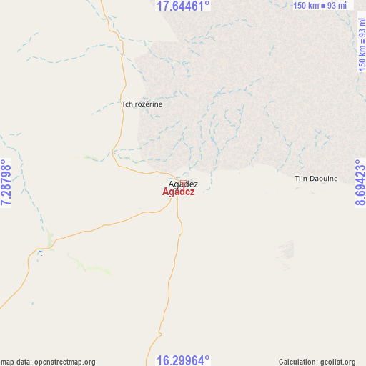
Agadez GPS coordinates[2]
16° 58' 23.988" North, 7° 59' 27.996" East
| Map corner | latitude | longitude |
|---|---|---|
| Upper-left | 17.64461°, | 7.28798° |
| Center: | 16.97333°, | 7.99111° |
| Lower-right: | 16.29964°, | 8.69423° |
| Map W x H: | 149.5×149.5 km | = 92.9×92.9mi |
| max Lat: | 18.73694° ⇑9.3% North |
| Agadez: | 16.97333° |
| min Lat: | ⇓90.7% South 11.88435° |
| min Long | Agadez | max Long |
| 0.75306° | 7.99111° | 13.10921° |
| W 72.1%⇐ | ⇒27.9% E |
Elevation
Elevation of Agadez is 505 m = 1657 ft, and this is 162.2 m = 532 ft above average elevation for this country.
| Max E: |
525 m = 1722 ft | 7% |
| Agadez | 505 m 1657 ft | |
| Avg. | 342.8 m = 1125 ft | |
Min E: |
177 m = 581 ft | 93% |
See also: Agadez elevation on elevation.city.
Geographical zone
Agadez is located in North Torrid zone (between Equator and Tropic of Cancer). Distance of this Northern Tropic circle is 718.7 km =446.6 mi to North.| Distance of | km | miles | from Agadez |
|---|---|---|---|
| North Pole | 8119.8 | 5045.4 | to North |
| Arctic Circle | 5513.9 | 3426.2 | to North |
| Tropic Cancer | 718.7 | 446.6 | to North |
| Equator | 1887.3 | 1172.7 | to South |


Nearby cities:
15 places around Agadez: (largest is in red/bold)
• Abalak
249.1 km =154.8 mi,  227°
227°
• Alaghsas
5.7 km =3.5 mi,  28°
28°
• Arlit
206.3 km =128.2 mi,  341°
341°
• Bouza
352 km =218.7 mi,  216°
216°
• Dakoro
303.6 km =188.6 mi,  205°
205°
• Kantché
385.2 km =239.4 mi,  172°
172°
• Keïta
342.1 km =212.6 mi, 223°
• Mayahi
337.3 km =209.6 mi,  185°
185°
• Mirriah
383.8 km =238.5 mi,  161°
161°
• Tahoua
372 km =231.2 mi, 231°
• Tanout
242.4 km =150.6 mi, 156°
• Tchintabaraden
262.7 km =163.2 mi,  242°
242°
• Tchirozérine
36.8 km =22.9 mi,  318°
318°
• Tessaoua
357.6 km =222.2 mi,  180°
180°
• Zinder
367.9 km =228.6 mi, 163°
Sources, notices
• [Note1] Compared only with cities in Niger existing in our database
• [Src1] Map data: © OpenStreetMap contributors (CC-BY-SA)
• [Src2] Other city data from geonames.org with taken over terms of usage.
• [Src3] Geographical zone / Annual Mean Temperature by Robert A. Rohde @ Wikipedia
