Alaghsas geodata
Alaghsas (Agadez) is a populated place; located in Niger in Africa/Niamey (GMT+1) time zone. With population of 88,561 people, there are 4 cities with bigger population in this country. Compared to other cities in Niger, 93% of cities are located further ↓South; 74.4% of cities are located further ←West and 97.7% of cities have lower elevation than Alaghsas. Note1


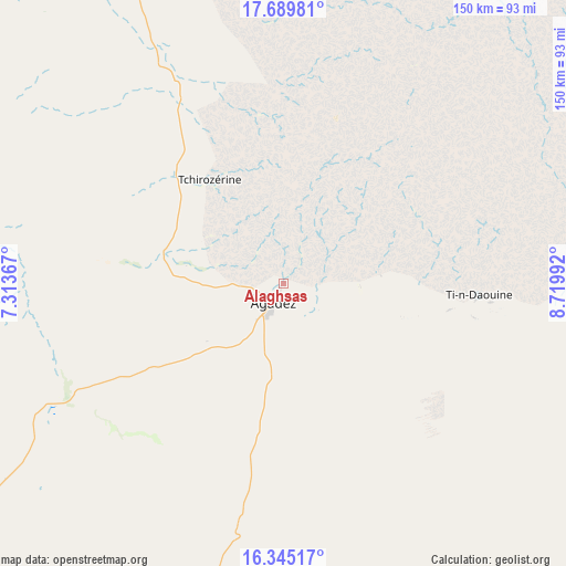
Alaghsas GPS coordinates[2]
17° 1' 7.32" North, 8° 1' 0.48" East
| Map corner | latitude | longitude |
|---|---|---|
| Upper-left | 17.68981°, | 7.31367° |
| Center: | 17.0187°, | 8.0168° |
| Lower-right: | 16.34517°, | 8.71992° |
| Map W x H: | 149.5×149.5 km | = 92.9×92.9mi |
| max Lat: | 18.73694° ⇑7% North |
| Alaghsas: | 17.0187° |
| min Lat: | ⇓93% South 11.88435° |
| min Long | Alaghsas | max Long |
| 0.75306° | 8.0168° | 13.10921° |
| W 74.4%⇐ | ⇒25.6% E |
Elevation
Elevation of Alaghsas is 519 m = 1703 ft, and this is 176.2 m = 578 ft above average elevation for this country.
| Max E: |
525 m = 1722 ft | 2.3% |
| Alaghsas | 519 m 1703 ft | |
| Avg. | 342.8 m = 1125 ft | |
Min E: |
177 m = 581 ft | 97.7% |
See also: Alaghsas elevation on elevation.city.
Geographical zone
Alaghsas is located in North Torrid zone (between Equator and Tropic of Cancer). Distance of this Northern Tropic circle is 713.6 km =443.4 mi to North.| Distance of | km | miles | from Alaghsas |
|---|---|---|---|
| North Pole | 8114.8 | 5042.3 | to North |
| Arctic Circle | 5508.9 | 3423.1 | to North |
| Tropic Cancer | 713.6 | 443.4 | to North |
| Equator | 1892.3 | 1175.8 | to South |


Nearby cities:
15 places around Alaghsas: (largest is in red/bold)
• Abalak
254.5 km =158.1 mi,  226°
226°
• Agadez
5.7 km =3.5 mi,  208°
208°
• Arlit
202.4 km =125.8 mi,  340°
340°
• Bouza
357.7 km =222.3 mi,  216°
216°
• Dakoro
309.4 km =192.3 mi, 205°
• Kantché
389.8 km =242.2 mi,  172°
172°
• Keïta
347.6 km =216 mi, 223°
• Mayahi
342.6 km =212.9 mi,  186°
186°
• Mirriah
387.7 km =240.9 mi,  161°
161°
• Tahoua
377.3 km =234.4 mi, 231°
• Tanout
246 km =152.9 mi, 157°
• Tchintabaraden
267.4 km =166.2 mi,  242°
242°
• Tchirozérine
35.2 km =21.9 mi,  309°
309°
• Tessaoua
362.6 km =225.3 mi,  180°
180°
• Zinder
372 km =231.2 mi, 163°
Sources, notices
• [Note1] Compared only with cities in Niger existing in our database
• [Src1] Map data: © OpenStreetMap contributors (CC-BY-SA)
• [Src2] Other city data from geonames.org with taken over terms of usage.
• [Src3] Geographical zone / Annual Mean Temperature by Robert A. Rohde @ Wikipedia
