Dogondoutchi geodata
Dogondoutchi (Dosso) is a seat of a second-order administrative division; located in Niger in Africa/Niamey (GMT+1) time zone. With population of 31,767 people, there are 10 cities with bigger population in this country. Compared to other cities in Niger, 62.8% of cities are located further ↑North; 72.1% of cities are located further →East and 76.7% of cities have higher elevation than Dogondoutchi. Note1


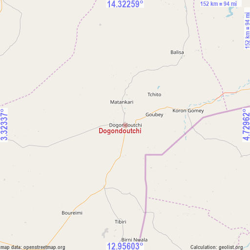
Dogondoutchi GPS coordinates[2]
13° 38' 25.08" North, 4° 1' 35.364" East
| Map corner | latitude | longitude |
|---|---|---|
| Upper-left | 14.32259°, | 3.32337° |
| Center: | 13.6403°, | 4.02649° |
| Lower-right: | 12.95603°, | 4.72962° |
| Map W x H: | 151.9×152 km | = 94.4×94.4mi |
| max Lat: | 18.73694° ⇑62.8% North |
| Dogondoutchi: | 13.6403° |
| min Lat: | ⇓37.2% South 11.88435° |
| min Long | Dogondoutchi | max Long |
| 0.75306° | 4.02649° | 13.10921° |
| W 27.9%⇐ | ⇒72.1% E |
Elevation
Elevation of Dogondoutchi is 228 m = 748 ft, and this is 114.8 m = 377 ft below average elevation for this country.
| Max E: |
525 m = 1722 ft | 76.7% |
| Avg. | 342.8 m = 1125 ft | |
| Dogondoutchi | 228 m = 748 ft | |
Min E: |
177 m = 581 ft | 23.3% |
See also: Niger elevation on elevation.city.
Geographical zone
Dogondoutchi is located in North Torrid zone (between Equator and Tropic of Cancer). Distance of this Northern Tropic circle is 1089.3 km =676.9 mi to North.| Distance of | km | miles | from Dogondoutchi |
|---|---|---|---|
| North Pole | 8490.4 | 5275.7 | to North |
| Arctic Circle | 5884.5 | 3656.5 | to North |
| Tropic Cancer | 1089.3 | 676.9 | to North |
| Equator | 1516.7 | 942.4 | to South |


Nearby cities:
15 places around Dogondoutchi: (largest is in red/bold)
• Birni N Konni
133.3 km =82.8 mi,  82°
82°
• Birnin Gaouré
135.7 km =84.3 mi,  242°
242°
• Bouza
234.3 km =145.6 mi,  68°
68°
• Dosso
111.5 km =69.3 mi,  233°
233°
• Filingué
110.1 km =68.4 mi,  315°
315°
• Gaya
205 km =127.4 mi,  197°
197°
• Illéla
159.9 km =99.4 mi,  55°
55°
• Keïta
225.6 km =140.2 mi, 56°
• Kollo
186.3 km =115.8 mi,  258°
258°
• Loga
85.5 km =53.1 mi,  267°
267°
• Madaoua
214.2 km =133.1 mi, 77°
• Niamey
207.6 km =129 mi, 266°
• Ouallam
222.5 km =138.3 mi,  289°
289°
• Say
189.1 km =117.5 mi,  251°
251°
• Tahoua
192.9 km =119.9 mi,  43°
43°
Sources, notices
• [Note1] Compared only with cities in Niger existing in our database
• [Src1] Map data: © OpenStreetMap contributors (CC-BY-SA)
• [Src2] Other city data from geonames.org with taken over terms of usage.
• [Src3] Geographical zone / Annual Mean Temperature by Robert A. Rohde @ Wikipedia
