Loga geodata
Loga (Dosso) is a seat of a second-order administrative division; located in Niger in Africa/Niamey (GMT+1) time zone. In our database, there are 38 cities with bigger population. Compared to other cities in Niger, 65.1% of cities are located further ↑North; 79.1% of cities are located further →East and 83.7% of cities have higher elevation than Loga. Note1


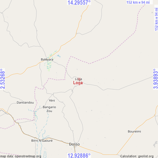
Loga GPS coordinates[2]
13° 36' 47.52" North, 3° 14' 8.88" East
| Map corner | latitude | longitude |
|---|---|---|
| Upper-left | 14.29557°, | 2.53268° |
| Center: | 13.6132°, | 3.2358° |
| Lower-right: | 12.92886°, | 3.93893° |
| Map W x H: | 152×152 km | = 94.4×94.4mi |
| max Lat: | 18.73694° ⇑65.1% North |
| Loga: | 13.6132° |
| min Lat: | ⇓34.9% South 11.88435° |
| min Long | Loga | max Long |
| 0.75306° | 3.2358° | 13.10921° |
| W 20.9%⇐ | ⇒79.1% E |
Elevation
Elevation of Loga is 222 m = 728 ft, and this is 120.8 m = 396 ft below average elevation for this country.
| Max E: |
525 m = 1722 ft | 83.7% |
| Avg. | 342.8 m = 1125 ft | |
| Loga | 222 m = 728 ft | |
Min E: |
177 m = 581 ft | 16.3% |
See also: Niger elevation on elevation.city.
Geographical zone
Loga is located in North Torrid zone (between Equator and Tropic of Cancer). Distance of this Northern Tropic circle is 1092.3 km =678.7 mi to North.| Distance of | km | miles | from Loga |
|---|---|---|---|
| North Pole | 8493.4 | 5277.6 | to North |
| Arctic Circle | 5887.5 | 3658.3 | to North |
| Tropic Cancer | 1092.3 | 678.7 | to North |
| Equator | 1513.6 | 940.5 | to South |


Nearby cities:
15 places around Loga: (largest is in red/bold)
• Ayorou
279.1 km =173.4 mi,  296°
296°
• Birni N Konni
218.6 km =135.8 mi,  84°
84°
• Birnin Gaouré
68.8 km =42.8 mi,  210°
210°
• Dogondoutchi
85.5 km =53.1 mi,  87°
87°
• Dosso
62.9 km =39.1 mi,  184°
184°
• Filingué
82.6 km =51.3 mi,  6°
6°
• Gaya
193.6 km =120.3 mi,  173°
173°
• Illéla
236.2 km =146.8 mi,  66°
66°
• Kollo
102.9 km =63.9 mi,  250°
250°
• Niamey
122.2 km =75.9 mi,  264°
264°
• Ouallam
146.7 km =91.2 mi, 302°
• Say
109.7 km =68.2 mi,  238°
238°
• Tahoua
261 km =162.2 mi,  57°
57°
• Tillabéri
203.3 km =126.3 mi,  288°
288°
• Téra
271.6 km =168.8 mi,  279°
279°
Sources, notices
• [Note1] Compared only with cities in Niger existing in our database
• [Src1] Map data: © OpenStreetMap contributors (CC-BY-SA)
• [Src2] Other city data from geonames.org with taken over terms of usage.
• [Src3] Geographical zone / Annual Mean Temperature by Robert A. Rohde @ Wikipedia
