Bassa geodata
Bassa (Plateau) is a seat of a second-order administrative division; located in Nigeria in Africa/Lagos (GMT+1) time zone. In our database, there are 451 cities with bigger population. Compared to other cities in Nigeria, 63.9% of cities are located further ↓South; 74.1% of cities are located further ←West and 99.1% of cities have lower elevation than Bassa. Note1


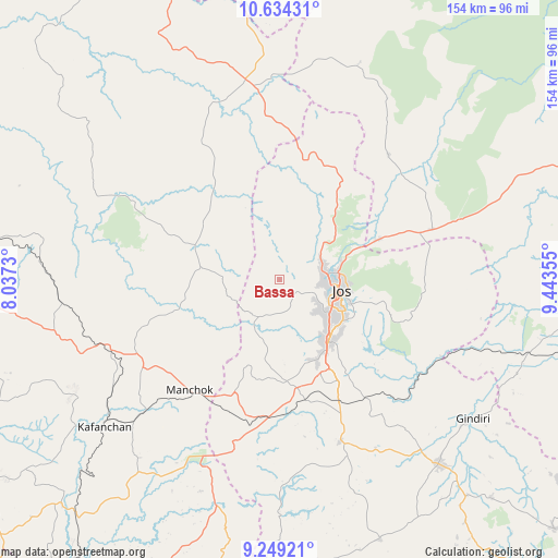
Bassa GPS coordinates[2]
9° 56' 32.964" North, 8° 44' 25.512" East
| Map corner | latitude | longitude |
|---|---|---|
| Upper-left | 10.63431°, | 8.0373° |
| Center: | 9.94249°, | 8.74042° |
| Lower-right: | 9.24921°, | 9.44355° |
| Map W x H: | 154×154 km | = 95.7×95.7mi |
| max Lat: | 13.7543° ⇑36.1% North |
| Bassa: | 9.94249° |
| min Lat: | ⇓63.9% South 4.31231° |
| min Long | Bassa | max Long |
| 2.73333° | 8.74042° | 14.46552° |
| W 74.1%⇐ | ⇒25.9% E |
Elevation
Elevation of Bassa is 1168 m = 3832 ft, and this is 871.5 m = 2859 ft above average elevation for this country.
| Max E: |
1599 m = 5246 ft | 0.90000000000001% |
| Bassa | 1168 m 3832 ft | |
| Avg. | 296.5 m = 973 ft | |
Min E: |
2 m = 7 ft | 99.1% |
See also: Nigeria elevation on elevation.city.
Geographical zone
Bassa is located in North Torrid zone (between Equator and Tropic of Cancer). Distance of Equator is 1105.5 km =686.9 mi to South.| Distance of | km | miles | from Bassa |
|---|---|---|---|
| North Pole | 8901.6 | 5531.2 | to North |
| Arctic Circle | 6295.7 | 3912 | to North |
| Tropic Cancer | 1500.4 | 932.3 | to North |
| Equator | 1105.5 | 686.9 | to South |


Nearby cities:
15 places around Bassa: (largest is in red/bold)
• Angware
40.6 km =25.2 mi,  82°
82°
• Barkin Ladi
48 km =29.8 mi,  159°
159°
• Bukuru
21.3 km =13.2 mi,  140°
140°
• Jos
16.7 km =10.4 mi,  95°
95°
• Kafanchan
63.4 km =39.4 mi,  230°
230°
• Kagoro
53.4 km =33.2 mi, 225°
• Kaura
43.4 km =27 mi, 225°
• Lere
52.6 km =32.7 mi,  339°
339°
• Lere
70.6 km =43.9 mi,  111°
111°
• Mangu
61.1 km =38 mi, 140°
• Riyom
34 km =21.1 mi,  176°
176°
• Saminaka
52.6 km =32.7 mi,  353°
353°
• Toro
38.2 km =23.7 mi,  70°
70°
• Vom
24.4 km =15.2 mi,  166°
166°
• Zonkwa
52.3 km =32.5 mi,  250°
250°
Sources, notices
• [Note1] Compared only with cities in Nigeria existing in our database
• [Src1] Map data: © OpenStreetMap contributors (CC-BY-SA)
• [Src2] Other city data from geonames.org with taken over terms of usage.
• [Src3] Geographical zone / Annual Mean Temperature by Robert A. Rohde @ Wikipedia
