Forsand geodata
Forsand (Rogaland) is a seat of a second-order administrative division; located in Norway in Europe/Oslo (GMT+2) time zone. In our database, there are 488 cities with bigger population. Compared to other cities in Norway, 91% of cities are located further ↑North; 81.8% of cities are located further →East and 51.6% of cities have lower elevation than Forsand. Note1


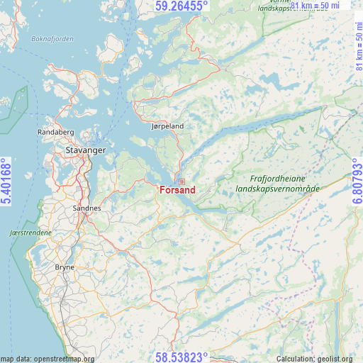
Forsand GPS coordinates[2]
58° 54' 11.88" North, 6° 6' 17.28" East
| Map corner | latitude | longitude |
|---|---|---|
| Upper-left | 59.26455°, | 5.40168° |
| Center: | 58.9033°, | 6.1048° |
| Lower-right: | 58.53823°, | 6.80793° |
| Map W x H: | 80.8×80.8 km | = 50.2×50.2mi |
| max Lat: | 71.04137° ⇑91% North |
| Forsand: | 58.9033° |
| min Lat: | ⇓9% South 58.0274° |
| min Long | Forsand | max Long |
| 4.71485° | 6.1048° | 31.11066° |
| W 18.2%⇐ | ⇒81.8% E |
Elevation
Elevation of Forsand is 46 m = 151 ft, and this is 58.2 m = 191 ft below average elevation for this country.
| Max E: |
897 m = 2943 ft | 48.4% |
| Avg. | 104.2 m = 342 ft | |
| Forsand | 46 m = 151 ft | |
Min E: |
1 m = 3 ft | 51.6% |
See also: Norway elevation on elevation.city.
Geographical zone
Forsand is located in North temperate zone (between Tropic of Cancer and the Arctic Circle). Distance of this North polar circle is 851.7 km =529.2 mi to North.| Distance of | km | miles | from Forsand |
|---|---|---|---|
| North Pole | 3457.6 | 2148.5 | to North |
| Arctic Circle | 851.7 | 529.2 | to North |
| Tropic Cancer | 3943.5 | 2450.4 | to South |
| Equator | 6549.4 | 4069.6 | to South |


Nearby cities:
15 places around Forsand: (largest is in red/bold)
• Bryne
32.3 km =20.1 mi,  234°
234°
• Hommersåk
14.8 km =9.2 mi,  279°
279°
• Jørpeland
13.8 km =8.6 mi,  344°
344°
• Kleppe
30.9 km =19.2 mi,  242°
242°
• Lyefjell
28.3 km =17.6 mi, 228°
• Oltedal
9.2 km =5.7 mi,  205°
205°
• Randaberg
29.9 km =18.6 mi,  291°
291°
• Sandnes
22 km =13.7 mi,  255°
255°
• Sola
26 km =16.2 mi,  266°
266°
• Stavanger
22.6 km =14 mi, 289°
• Tananger
30.7 km =19.1 mi, 276°
• Tau
20.8 km =12.9 mi,  329°
329°
• Vikeså
29.6 km =18.4 mi,  181°
181°
• Vikevåg
31.8 km =19.8 mi,  312°
312°
• Ålgård
21.2 km =13.2 mi,  223°
223°
Sources, notices
• [Note1] Compared only with cities in Norway existing in our database
• [Src1] Map data: © OpenStreetMap contributors (CC-BY-SA)
• [Src2] Other city data from geonames.org with taken over terms of usage.
• [Src3] Geographical zone / Annual Mean Temperature by Robert A. Rohde @ Wikipedia
