Jørpeland geodata
Jørpeland (Rogaland) is a seat of a second-order administrative division; located in Norway in Europe/Oslo (GMT+2) time zone. With population of 5,537 people, there are 84 cities with bigger population in this country. Compared to other cities in Norway, 89.7% of cities are located further ↑North; 82.4% of cities are located further →East and 63.3% of cities have higher elevation than Jørpeland. Note1


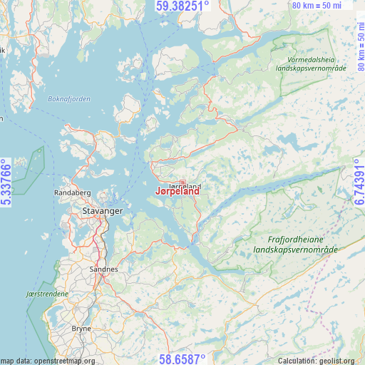
Jørpeland GPS coordinates[2]
59° 1' 21.036" North, 6° 2' 26.808" East
| Map corner | latitude | longitude |
|---|---|---|
| Upper-left | 59.38251°, | 5.33766° |
| Center: | 59.02251°, | 6.04078° |
| Lower-right: | 58.6587°, | 6.74391° |
| Map W x H: | 80.5×80.5 km | = 50×50mi |
| max Lat: | 71.04137° ⇑89.7% North |
| Jørpeland: | 59.02251° |
| min Lat: | ⇓10.3% South 58.0274° |
| min Long | Jørpeland | max Long |
| 4.71485° | 6.04078° | 31.11066° |
| W 17.6%⇐ | ⇒82.4% E |
Elevation
Elevation of Jørpeland is 24 m = 79 ft, and this is 80.2 m = 263 ft below average elevation for this country.
| Max E: |
897 m = 2943 ft | 63.3% |
| Avg. | 104.2 m = 342 ft | |
| Jørpeland | 24 m = 79 ft | |
Min E: |
1 m = 3 ft | 36.7% |
See also: Norway elevation on elevation.city.
Geographical zone
Jørpeland is located in North temperate zone (between Tropic of Cancer and the Arctic Circle). Distance of this North polar circle is 838.5 km =521 mi to North.| Distance of | km | miles | from Jørpeland |
|---|---|---|---|
| North Pole | 3444.4 | 2140.3 | to North |
| Arctic Circle | 838.5 | 521 | to North |
| Tropic Cancer | 3956.8 | 2458.6 | to South |
| Equator | 6562.7 | 4077.9 | to South |


Nearby cities:
15 places around Jørpeland: (largest is in red/bold)
• Forsand
13.8 km =8.6 mi,  164°
164°
• Hjelmelandsvågen
25.1 km =15.6 mi,  18°
18°
• Hommersåk
15.3 km =9.5 mi,  225°
225°
• Judaberg
19.1 km =11.9 mi,  330°
330°
• Kleppe
36.3 km =22.6 mi,  220°
220°
• Lyefjell
36.4 km =22.6 mi,  208°
208°
• Oltedal
21.6 km =13.4 mi,  180°
180°
• Randaberg
24.3 km =15.1 mi,  263°
263°
• Sandnes
25.8 km =16 mi, 222°
• Sola
26.8 km =16.7 mi,  236°
236°
• Stavanger
18.6 km =11.6 mi,  251°
251°
• Tananger
28.4 km =17.6 mi, 250°
• Tau
8.2 km =5.1 mi,  304°
304°
• Vikevåg
21.3 km =13.2 mi,  293°
293°
• Ålgård
30.7 km =19.1 mi,  200°
200°
Sources, notices
• [Note1] Compared only with cities in Norway existing in our database
• [Src1] Map data: © OpenStreetMap contributors (CC-BY-SA)
• [Src2] Other city data from geonames.org with taken over terms of usage.
• [Src3] Geographical zone / Annual Mean Temperature by Robert A. Rohde @ Wikipedia
