Ålgård geodata
Ålgård (Rogaland) is a seat of a second-order administrative division; located in Norway in Europe/Oslo (GMT+2) time zone. In our database, there are 488 cities with bigger population. Compared to other cities in Norway, 92.6% of cities are located further ↑North; 84.7% of cities are located further →East and 68.5% of cities have lower elevation than Ålgård. Note1


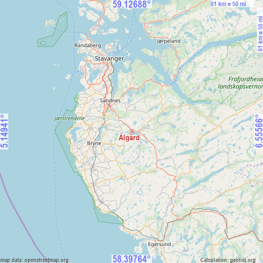
Ålgård GPS coordinates[2]
58° 45' 51.012" North, 5° 51' 9.108" East
| Map corner | latitude | longitude |
|---|---|---|
| Upper-left | 59.12688°, | 5.14941° |
| Center: | 58.76417°, | 5.85253° |
| Lower-right: | 58.39764°, | 6.55566° |
| Map W x H: | 81.1×81.1 km | = 50.4×50.4mi |
| max Lat: | 71.04137° ⇑92.6% North |
| Ålgård: | 58.76417° |
| min Lat: | ⇓7.4% South 58.0274° |
| min Long | Ålgård | max Long |
| 4.71485° | 5.85253° | 31.11066° |
| W 15.3%⇐ | ⇒84.7% E |
Elevation
Elevation of Ålgård is 116 m = 381 ft, and this is 11.8 m = 39 ft above average elevation for this country.
| Max E: |
897 m = 2943 ft | 31.5% |
| Ålgård | 116 m 381 ft | |
| Avg. | 104.2 m = 342 ft | |
Min E: |
1 m = 3 ft | 68.5% |
See also: Norway elevation on elevation.city.
Geographical zone
Ålgård is located in North temperate zone (between Tropic of Cancer and the Arctic Circle). Distance of this North polar circle is 867.2 km =538.9 mi to North.| Distance of | km | miles | from Ålgård |
|---|---|---|---|
| North Pole | 3473.1 | 2158.1 | to North |
| Arctic Circle | 867.2 | 538.9 | to North |
| Tropic Cancer | 3928 | 2440.7 | to South |
| Equator | 6534 | 4060 | to South |


Nearby cities:
15 places around Ålgård: (largest is in red/bold)
• Bryne
12.2 km =7.6 mi,  254°
254°
• Forsand
21.2 km =13.2 mi,  43°
43°
• Hommersåk
17.9 km =11.1 mi,  359°
359°
• Kleppe
12.9 km =8 mi,  274°
274°
• Lyefjell
7.4 km =4.6 mi,  244°
244°
• Nærbø
16.6 km =10.3 mi,  228°
228°
• Oltedal
12.8 km =8 mi,  55°
55°
• Randaberg
29.4 km =18.3 mi,  332°
332°
• Sandnes
11.9 km =7.4 mi, 325°
• Sola
18 km =11.2 mi,  320°
320°
• Stavanger
23.9 km =14.9 mi,  343°
343°
• Tananger
24.9 km =15.5 mi, 320°
• Varhaug
19.8 km =12.3 mi,  214°
214°
• Vigrestad
23.6 km =14.7 mi,  204°
204°
• Vikeså
19.7 km =12.2 mi,  135°
135°
Sources, notices
• [Note1] Compared only with cities in Norway existing in our database
• [Src1] Map data: © OpenStreetMap contributors (CC-BY-SA)
• [Src2] Other city data from geonames.org with taken over terms of usage.
• [Src3] Geographical zone / Annual Mean Temperature by Robert A. Rohde @ Wikipedia
