Kleppe geodata
Kleppe (Rogaland) is a seat of a second-order administrative division; located in Norway in Europe/Oslo (GMT+2) time zone. In our database, there are 488 cities with bigger population. Compared to other cities in Norway, 92.2% of cities are located further ↑North; 88.6% of cities are located further →East and 51.1% of cities have lower elevation than Kleppe. Note1


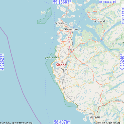
Kleppe GPS coordinates[2]
58° 46' 27.228" North, 5° 37' 45.696" East
| Map corner | latitude | longitude |
|---|---|---|
| Upper-left | 59.13683°, | 4.92623° |
| Center: | 58.77423°, | 5.62936° |
| Lower-right: | 58.4078°, | 6.33248° |
| Map W x H: | 81.1×81.1 km | = 50.4×50.4mi |
| max Lat: | 71.04137° ⇑92.2% North |
| Kleppe: | 58.77423° |
| min Lat: | ⇓7.8% South 58.0274° |
| min Long | Kleppe | max Long |
| 4.71485° | 5.62936° | 31.11066° |
| W 11.4%⇐ | ⇒88.6% E |
Elevation
Elevation of Kleppe is 44 m = 144 ft, and this is 60.2 m = 198 ft below average elevation for this country.
| Max E: |
897 m = 2943 ft | 48.9% |
| Avg. | 104.2 m = 342 ft | |
| Kleppe | 44 m = 144 ft | |
Min E: |
1 m = 3 ft | 51.1% |
See also: Norway elevation on elevation.city.
Geographical zone
Kleppe is located in North temperate zone (between Tropic of Cancer and the Arctic Circle). Distance of this North polar circle is 866.1 km =538.2 mi to North.| Distance of | km | miles | from Kleppe |
|---|---|---|---|
| North Pole | 3472 | 2157.4 | to North |
| Arctic Circle | 866.1 | 538.2 | to North |
| Tropic Cancer | 3929.2 | 2441.5 | to South |
| Equator | 6535.1 | 4060.7 | to South |


Nearby cities:
15 places around Kleppe: (largest is in red/bold)
• Bryne
4.4 km =2.7 mi,  166°
166°
• Forsand
30.9 km =19.2 mi,  62°
62°
• Hommersåk
21.1 km =13.1 mi,  37°
37°
• Lyefjell
7.5 km =4.7 mi,  125°
125°
• Nærbø
12.1 km =7.5 mi,  177°
177°
• Oltedal
24.2 km =15 mi,  75°
75°
• Randaberg
25.1 km =15.6 mi,  358°
358°
• Sandnes
10.6 km =6.6 mi, 35°
• Sola
12.8 km =8 mi,  6°
6°
• Stavanger
22.6 km =14 mi,  15°
15°
• Tananger
18.3 km =11.4 mi,  349°
349°
• Varhaug
17.4 km =10.8 mi, 174°
• Vigrestad
22.8 km =14.2 mi, 172°
• Vikeså
30.7 km =19.1 mi,  119°
119°
• Ålgård
12.9 km =8 mi,  94°
94°
Sources, notices
• [Note1] Compared only with cities in Norway existing in our database
• [Src1] Map data: © OpenStreetMap contributors (CC-BY-SA)
• [Src2] Other city data from geonames.org with taken over terms of usage.
• [Src3] Geographical zone / Annual Mean Temperature by Robert A. Rohde @ Wikipedia
