Dombås geodata
Dombås (Oppland) is a populated place; located in Norway in Europe/Oslo (GMT+2) time zone. With population of 1,156 people, there are 281 cities with bigger population in this country. Compared to other cities in Norway, 64.4% of cities are located further ↓South; 58.5% of cities are located further →East and 99.2% of cities have lower elevation than Dombås. Note1


Dombås GPS coordinates[2]
62° 4' 31.944" North, 9° 7' 40.26" East
| Map corner | latitude | longitude |
|---|---|---|
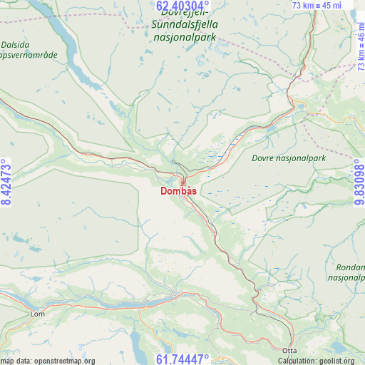
| Upper-left | 62.40304°, | 8.42473° |
| Center: | 62.07554°, | 9.12785° |
| Lower-right: | 61.74447°, | 9.83098° |
| Map W x H: | 73.2×73.2 km | = 45.5×45.5mi |
| max Lat: | 71.04137° ⇑35.6% North |
| Dombås: | 62.07554° |
| min Lat: | ⇓64.4% South 58.0274° |
| min Long | Dombås | max Long |
| 4.71485° | 9.12785° | 31.11066° |
| W 41.5%⇐ | ⇒58.5% E |
Elevation
Elevation of Dombås is 700 m = 2297 ft, and this is 595.8 m = 1955 ft above average elevation for this country.
| Max E: |
897 m = 2943 ft | 0.8% |
| Dombås | 700 m 2297 ft | |
| Avg. | 104.2 m = 342 ft | |
Min E: |
1 m = 3 ft | 99.2% |
See also: Norway elevation on elevation.city.
Geographical zone
Dombås is located in North temperate zone (between Tropic of Cancer and the Arctic Circle). Distance of this North polar circle is 499 km =310.1 mi to North.| Distance of | km | miles | from Dombås |
|---|---|---|---|
| North Pole | 3104.9 | 1929.3 | to North |
| Arctic Circle | 499 | 310.1 | to North |
| Tropic Cancer | 4296.2 | 2669.5 | to South |
| Equator | 6902.2 | 4288.8 | to South |


Nearby cities:
15 places around Dombås: (largest is in red/bold)
• Bismo
49.8 km =30.9 mi,  244°
244°
• Bismoen
49.8 km =30.9 mi, 244°
• Dale
38.5 km =23.9 mi,  150°
150°
• Dovre
11.8 km =7.3 mi, 145°
• Folldal
45.6 km =28.3 mi,  82°
82°
• Fossbergom
39.4 km =24.5 mi,  227°
227°
• Grøa
66.5 km =41.3 mi,  341°
341°
• Hundorp
71.9 km =44.7 mi,  143°
143°
• Kvam
54.3 km =33.7 mi, 147°
• Lesja
14.5 km =9 mi,  289°
289°
• Oppdal
64.6 km =40.1 mi,  26°
26°
• Otta
40 km =24.9 mi, 147°
• Sunndalsøra
72.8 km =45.2 mi, 336°
• Vinstra
62.7 km =39 mi, 148°
• Vågåmo
22.4 km =13.9 mi,  184°
184°
Sources, notices
• [Note1] Compared only with cities in Norway existing in our database
• [Src1] Map data: © OpenStreetMap contributors (CC-BY-SA)
• [Src2] Other city data from geonames.org with taken over terms of usage.
• [Src3] Geographical zone / Annual Mean Temperature by Robert A. Rohde @ Wikipedia
