Mortí geodata
Mortí (Darién) is a populated place; located in Panama in America/Panama (GMT-5) time zone. With population of 528 people, there are 464 cities with bigger population in this country. Compared to other cities in Panama, 77% of cities are located further ↓South; 97.9% of cities are located further ←West and 52.8% of cities have higher elevation than Mortí. Note1


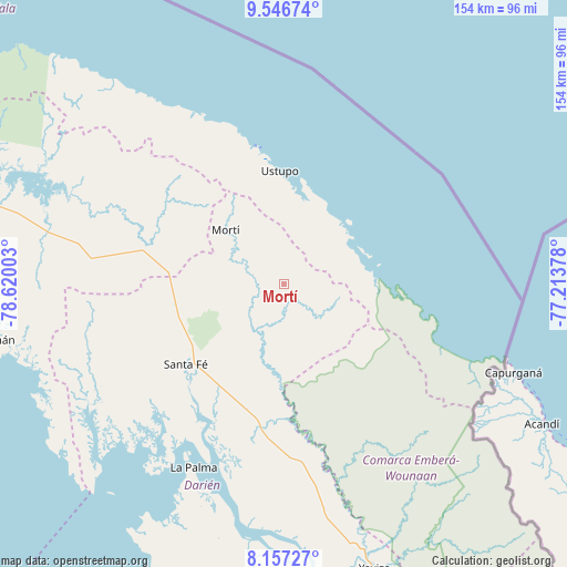
Mortí GPS coordinates[2]
8° 51' 9.576" North, 77° 55' 0.84" West
| Map corner | latitude | longitude |
|---|---|---|
| Upper-left | 9.54674°, | -78.62003° |
| Center: | 8.85266°, | -77.9169° |
| Lower-right: | 8.15727°, | -77.21378° |
| Map W x H: | 154.5×154.5 km | = 96×96mi |
| max Lat: | 9.60898° ⇑23% North |
| Mortí: | 8.85266° |
| min Lat: | ⇓77% South 7.26534° |
| min Long | Mortí | max Long |
| -82.91275° | -77.9169° | -77.38965° |
| W 97.9%⇐ | ⇒2.1% E |
Elevation
Elevation of Mortí is 67 m = 220 ft, and this is 105.1 m = 345 ft below average elevation for this country.
| Max E: |
2103 m = 6900 ft | 52.8% |
| Avg. | 172.1 m = 565 ft | |
| Mortí | 67 m = 220 ft | |
Min E: |
-1 m = -3 ft | 47.2% |
See also: Panama elevation on elevation.city.
Geographical zone
Mortí is located in North Torrid zone (between Equator and Tropic of Cancer). Distance of Equator is 984.3 km =611.6 mi to South.| Distance of | km | miles | from Mortí |
|---|---|---|---|
| North Pole | 9022.7 | 5606.4 | to North |
| Arctic Circle | 6416.9 | 3987.3 | to North |
| Tropic Cancer | 1621.6 | 1007.6 | to North |
| Equator | 984.3 | 611.6 | to South |


Nearby cities:
15 places around Mortí: (largest is in red/bold)
• Achutupo
39.2 km =24.4 mi,  348°
348°
• Agua Fría Número Uno
30.8 km =19.1 mi,  271°
271°
• Ailigandí
43.5 km =27 mi,  343°
343°
• Cañazas
34.2 km =21.3 mi,  278°
278°
• Coetupo
25.2 km =15.7 mi,  77°
77°
• Metetí
39.9 km =24.8 mi,  189°
189°
• Mortí
6.5 km =4 mi,  259°
259°
• Mulatupo
21 km =13 mi,  60°
60°
• Quebrada Honda
32.4 km =20.1 mi,  221°
221°
• Santa Fé
34.7 km =21.6 mi,  230°
230°
• Tubualá
22.5 km =14 mi,  70°
70°
• Ualá
21.6 km =13.4 mi,  313°
313°
• Ustupo
31 km =19.3 mi,  358°
358°
• Villa Darién
35.6 km =22.1 mi,  196°
196°
• Zapallal
32.5 km =20.2 mi, 226°
Sources, notices
• [Note1] Compared only with cities in Panama existing in our database
• [Src1] Map data: © OpenStreetMap contributors (CC-BY-SA)
• [Src2] Other city data from geonames.org with taken over terms of usage.
• [Src3] Geographical zone / Annual Mean Temperature by Robert A. Rohde @ Wikipedia
