Platanilla geodata
Platanilla (Darién) is a seat of a third-order administrative division; located in Panama in America/Panama (GMT-5) time zone. In our database, there are 694 cities with bigger population. Compared to other cities in Panama, 74.9% of cities are located further ↓South; 94.2% of cities are located further ←West and 62.6% of cities have lower elevation than Platanilla. Note1


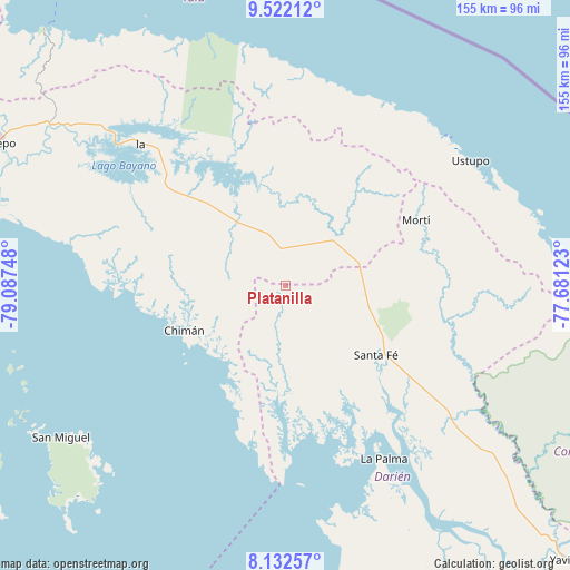
Platanilla GPS coordinates[2]
8° 49' 40.8" North, 78° 23' 3.66" West
| Map corner | latitude | longitude |
|---|---|---|
| Upper-left | 9.52212°, | -79.08748° |
| Center: | 8.828°, | -78.38435° |
| Lower-right: | 8.13257°, | -77.68123° |
| Map W x H: | 154.5×154.5 km | = 96×96mi |
| max Lat: | 9.60898° ⇑25.1% North |
| Platanilla: | 8.828° |
| min Lat: | ⇓74.9% South 7.26534° |
| min Long | Platanilla | max Long |
| -82.91275° | -78.38435° | -77.38965° |
| W 94.2%⇐ | ⇒5.8% E |
Elevation
Elevation of Platanilla is 117 m = 384 ft, and this is 55.1 m = 181 ft below average elevation for this country.
| Max E: |
2103 m = 6900 ft | 37.4% |
| Avg. | 172.1 m = 565 ft | |
| Platanilla | 117 m = 384 ft | |
Min E: |
-1 m = -3 ft | 62.6% |
See also: Panama elevation on elevation.city.
Geographical zone
Platanilla is located in North Torrid zone (between Equator and Tropic of Cancer). Distance of Equator is 981.6 km =609.9 mi to South.| Distance of | km | miles | from Platanilla |
|---|---|---|---|
| North Pole | 9025.5 | 5608.2 | to North |
| Arctic Circle | 6419.6 | 3989 | to North |
| Tropic Cancer | 1624.3 | 1009.3 | to North |
| Equator | 981.6 | 609.9 | to South |


Nearby cities:
15 places around Platanilla: (largest is in red/bold)
• Agua Fría Número Uno
20.8 km =12.9 mi,  80°
80°
• Barriales
27.1 km =16.8 mi,  180°
180°
• Brujas
31.4 km =19.5 mi,  210°
210°
• Cañazas
19.2 km =11.9 mi,  65°
65°
• Chimán
31.5 km =19.6 mi,  241°
241°
• Cucunatí
31.4 km =19.5 mi,  153°
153°
• Gonzalo Vásquez
46.6 km =29 mi,  189°
189°
• Ipetí
20.5 km =12.7 mi,  319°
319°
• Mortí
45 km =28 mi,  87°
87°
• Quebrada Honda
36.7 km =22.8 mi,  125°
125°
• Santa Fé
31.1 km =19.3 mi, 128°
• Tortí
10.6 km =6.6 mi,  347°
347°
• Ualá
39.6 km =24.6 mi,  63°
63°
• Unión Santeña
29.3 km =18.2 mi,  271°
271°
• Zapallal
34.3 km =21.3 mi, 125°
Sources, notices
• [Note1] Compared only with cities in Panama existing in our database
• [Src1] Map data: © OpenStreetMap contributors (CC-BY-SA)
• [Src2] Other city data from geonames.org with taken over terms of usage.
• [Src3] Geographical zone / Annual Mean Temperature by Robert A. Rohde @ Wikipedia
