Inahuaya geodata
Inahuaya (Loreto) is a seat of a third-order administrative division; located in Peru in America/Lima (GMT-5) time zone. In our database, there are 305 cities with bigger population. Compared to other cities in Peru, 78.3% of cities are located further ↓South; 55.5% of cities are located further ←West and 87.5% of cities have higher elevation than Inahuaya. Note1


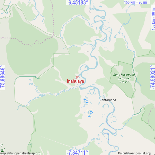
Inahuaya GPS coordinates[2]
7° 9' 0" South, 75° 16' 59.988" West
| Map corner | latitude | longitude |
|---|---|---|
| Upper-left | -6.45183°, | -75.98646° |
| Center: | -7.15°, | -75.28333° |
| Lower-right: | -7.84711°, | -74.58021° |
| Map W x H: | 155.1×155.1 km | = 96.4×96.4mi |
| max Lat: | -0.96667° ⇑21.7% North |
| Inahuaya: | -7.15° |
| min Lat: | ⇓78.3% South -18.01465° |
| min Long | Inahuaya | max Long |
| -81.30472° | -75.28333° | -69.04167° |
| W 55.5%⇐ | ⇒44.5% E |
Elevation
Elevation of Inahuaya is 139 m = 456 ft, and this is 2179.7 m = 7151 ft below average elevation for this country.
| Max E: |
5022 m = 16476 ft | 87.5% |
| Avg. | 2318.7 m = 7607 ft | |
| Inahuaya | 139 m = 456 ft | |
Min E: |
1 m = 3 ft | 12.5% |
See also: Peru elevation on elevation.city.
Geographical zone
Inahuaya is located in South Torrid zone (between Equator and Tropic of Capricorn). Distance of Equator is 795 km =494 mi to North.| Distance of | km | miles | from Inahuaya |
|---|---|---|---|
| Equator | 795 | 494 | to North |
| Tropic Capricorn | 1810.9 | 1125.2 | to South |
| Antarctic Circle | 6606.2 | 4104.9 | to South |
| South Pole | 9212.1 | 5724.1 | to South |


Nearby cities:
15 places around Inahuaya: (largest is in red/bold)
• Buenos Aires
121.8 km =75.7 mi,  289°
289°
• Chazuta
114.2 km =71 mi,  304°
304°
• Contamana
35.8 km =22.2 mi,  124°
124°
• Navarro
104.4 km =64.9 mi,  330°
330°
• Orellana
30.6 km =19 mi,  24°
24°
• Pampa Hermosa
5.9 km =3.7 mi,  198°
198°
• Pelejo
119.3 km =74.1 mi, 330°
• Picota
118.4 km =73.6 mi,  282°
282°
• Pilluana
118.6 km =73.7 mi, 290°
• Pucacaca
121.4 km =75.4 mi, 285°
• Sauce
114.8 km =71.3 mi, 296°
• Shamboyacu
94.8 km =58.9 mi, 278°
• Shapaja
125.3 km =77.9 mi, 300°
• Tres Unidos
111.2 km =69.1 mi, 290°
• Utcurarca
123.3 km =76.6 mi, 296°
Sources, notices
• [Note1] Compared only with cities in Peru existing in our database
• [Src1] Map data: © OpenStreetMap contributors (CC-BY-SA)
• [Src2] Other city data from geonames.org with taken over terms of usage.
• [Src3] Geographical zone / Annual Mean Temperature by Robert A. Rohde @ Wikipedia
