Oxapampa geodata
Oxapampa (Pasco) is a seat of a second-order administrative division; located in Peru in America/Lima (GMT-5) time zone. With population of 12,000 people, there are 132 cities with bigger population in this country. Compared to other cities in Peru, 57.4% of cities are located further ↓South; 53.8% of cities are located further ←West and 67.6% of cities have higher elevation than Oxapampa. Note1
Administrative division(s):
- Level 1: Pasco
- Level 2: Provincia de Oxapampa
- Level 3: Oxapampa District


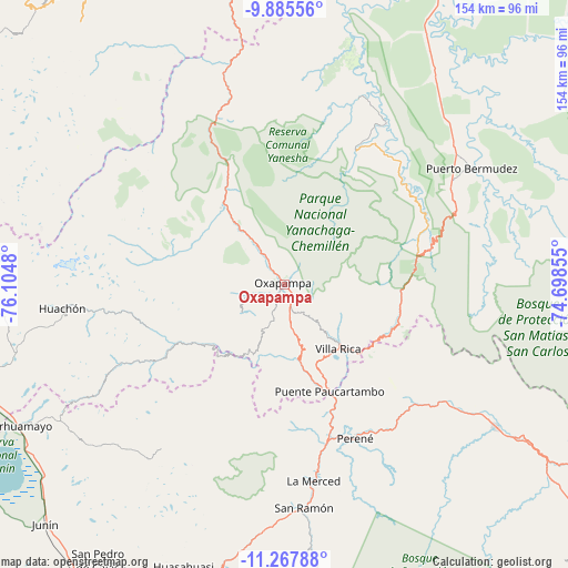
Oxapampa GPS coordinates[2]
10° 34' 39" South, 75° 24' 6.012" West
| Map corner | latitude | longitude |
|---|---|---|
| Upper-left | -9.88556°, | -76.1048° |
| Center: | -10.5775°, | -75.40167° |
| Lower-right: | -11.26788°, | -74.69855° |
| Map W x H: | 153.7×153.7 km | = 95.5×95.5mi |
| max Lat: | -0.96667° ⇑42.6% North |
| Oxapampa: | -10.5775° |
| min Lat: | ⇓57.4% South -18.01465° |
| min Long | Oxapampa | max Long |
| -81.30472° | -75.40167° | -69.04167° |
| W 53.8%⇐ | ⇒46.2% E |
Elevation
Elevation of Oxapampa is 1814 m = 5951 ft, and this is 504.7 m = 1656 ft below average elevation for this country.
| Max E: |
5022 m = 16476 ft | 67.6% |
| Avg. | 2318.7 m = 7607 ft | |
| Oxapampa | 1814 m = 5951 ft | |
Min E: |
1 m = 3 ft | 32.4% |
See also: Peru elevation on elevation.city.
Geographical zone
Oxapampa is located in South Torrid zone (between Equator and Tropic of Capricorn). Distance of Equator is 1176.1 km =730.8 mi to North.| Distance of | km | miles | from Oxapampa |
|---|---|---|---|
| Equator | 1176.1 | 730.8 | to North |
| Tropic Capricorn | 1429.8 | 888.4 | to South |
| Antarctic Circle | 6225.1 | 3868.1 | to South |
| South Pole | 8831 | 5487.3 | to South |


Nearby cities:
15 places around Oxapampa: (largest is in red/bold)
• Bajo Pichanaqui
69.5 km =43.2 mi,  124°
124°
• Carhuamayo
78.6 km =48.8 mi,  241°
241°
• Chontabamba
8.9 km =5.5 mi,  265°
265°
• Huancabamba
29.1 km =18.1 mi,  330°
330°
• Huariaca
87.5 km =54.4 mi,  279°
279°
• Huasahuasi
81 km =50.3 mi,  199°
199°
• La Merced
54.3 km =33.7 mi,  172°
172°
• Ninacaca
83.8 km =52.1 mi,  248°
248°
• Palca
87.4 km =54.3 mi,  192°
192°
• Palcamayo
89.5 km =55.6 mi,  206°
206°
• Paucartambo
49.7 km =30.9 mi, 244°
• Perené
45.2 km =28.1 mi,  154°
154°
• Pozuzo
58.6 km =36.4 mi,  345°
345°
• San Ramón
61 km =37.9 mi,  175°
175°
• Villa Rica
23.1 km =14.4 mi,  141°
141°
Sources, notices
• [Note1] Compared only with cities in Peru existing in our database
• [Src1] Map data: © OpenStreetMap contributors (CC-BY-SA)
• [Src2] Other city data from geonames.org with taken over terms of usage.
• [Src3] Geographical zone / Annual Mean Temperature by Robert A. Rohde @ Wikipedia
