Bajo Pichanaqui geodata
Bajo Pichanaqui (Junin) is a seat of a third-order administrative division; located in Peru in America/Lima (GMT-5) time zone. In our database, there are 305 cities with bigger population. Compared to other cities in Peru, 56% of cities are located further ↓South; 59.5% of cities are located further ←West and 77.6% of cities have higher elevation than Bajo Pichanaqui. Note1


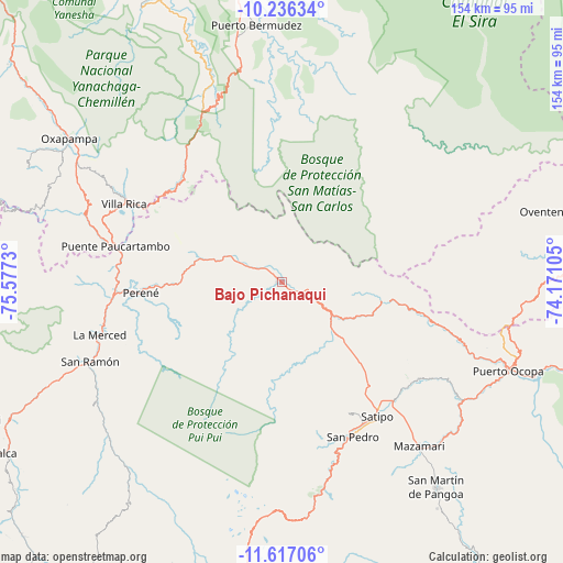
Bajo Pichanaqui GPS coordinates[2]
10° 55' 39" South, 74° 52' 27.012" West
| Map corner | latitude | longitude |
|---|---|---|
| Upper-left | -10.23634°, | -75.5773° |
| Center: | -10.9275°, | -74.87417° |
| Lower-right: | -11.61706°, | -74.17105° |
| Map W x H: | 153.5×153.5 km | = 95.4×95.4mi |
| max Lat: | -0.96667° ⇑44% North |
| Bajo Pichanaqui: | -10.9275° |
| min Lat: | ⇓56% South -18.01465° |
| min Long | Bajo Pichanaqui | max Long |
| -81.30472° | -74.87417° | -69.04167° |
| W 59.5%⇐ | ⇒40.5% E |
Elevation
Elevation of Bajo Pichanaqui is 511 m = 1677 ft, and this is 1807.7 m = 5931 ft below average elevation for this country.
| Max E: |
5022 m = 16476 ft | 77.6% |
| Avg. | 2318.7 m = 7607 ft | |
| Bajo Pichanaqui | 511 m = 1677 ft | |
Min E: |
1 m = 3 ft | 22.4% |
See also: Peru elevation on elevation.city.
Geographical zone
Bajo Pichanaqui is located in South Torrid zone (between Equator and Tropic of Capricorn). Distance of Equator is 1215 km =755 mi to North.| Distance of | km | miles | from Bajo Pichanaqui |
|---|---|---|---|
| Equator | 1215 | 755 | to North |
| Tropic Capricorn | 1390.9 | 864.3 | to South |
| Antarctic Circle | 6186.1 | 3843.9 | to South |
| South Pole | 8792 | 5463.1 | to South |


Nearby cities:
15 places around Bajo Pichanaqui: (largest is in red/bold)
• Andamarca
89.8 km =55.8 mi,  175°
175°
• Chontabamba
76.8 km =47.7 mi,  299°
299°
• Cochas
84.8 km =52.7 mi,  196°
196°
• Coviriali
48.7 km =30.3 mi,  146°
146°
• La Merced
52.5 km =32.6 mi,  253°
253°
• Mariposa
54.5 km =33.9 mi,  165°
165°
• Mazamari
58 km =36 mi,  139°
139°
• Mucllo
80.1 km =49.8 mi, 197°
• Oxapampa
69.5 km =43.2 mi, 304°
• Palca
88.9 km =55.2 mi,  238°
238°
• Perené
38.2 km =23.7 mi,  267°
267°
• Puerto Ocopa
66.7 km =41.4 mi,  111°
111°
• San Ramón
57.1 km =35.5 mi, 247°
• Satipo
44.3 km =27.5 mi, 144°
• Villa Rica
48 km =29.8 mi, 295°
Sources, notices
• [Note1] Compared only with cities in Peru existing in our database
• [Src1] Map data: © OpenStreetMap contributors (CC-BY-SA)
• [Src2] Other city data from geonames.org with taken over terms of usage.
• [Src3] Geographical zone / Annual Mean Temperature by Robert A. Rohde @ Wikipedia
