Perené geodata
Perené (Junin) is a populated place; located in Peru in America/Lima (GMT-5) time zone. With population of 6,844 people, there are 189 cities with bigger population in this country. Compared to other cities in Peru, 55.9% of cities are located further ↓South; 56.5% of cities are located further ←West and 76.5% of cities have higher elevation than Perené. Note1


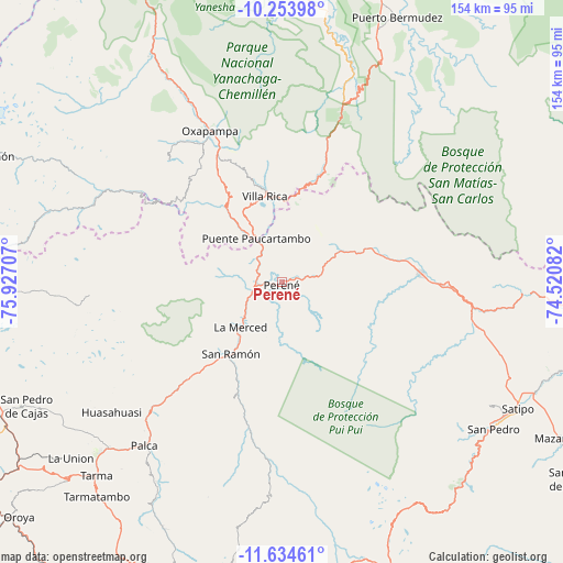
Perené GPS coordinates[2]
10° 56' 42.36" South, 75° 13' 26.184" West
| Map corner | latitude | longitude |
|---|---|---|
| Upper-left | -10.25398°, | -75.92707° |
| Center: | -10.9451°, | -75.22394° |
| Lower-right: | -11.63461°, | -74.52082° |
| Map W x H: | 153.5×153.5 km | = 95.4×95.4mi |
| max Lat: | -0.96667° ⇑44.1% North |
| Perené: | -10.9451° |
| min Lat: | ⇓55.9% South -18.01465° |
| min Long | Perené | max Long |
| -81.30472° | -75.22394° | -69.04167° |
| W 56.5%⇐ | ⇒43.5% E |
Elevation
Elevation of Perené is 612 m = 2008 ft, and this is 1706.7 m = 5599 ft below average elevation for this country.
| Max E: |
5022 m = 16476 ft | 76.5% |
| Avg. | 2318.7 m = 7607 ft | |
| Perené | 612 m = 2008 ft | |
Min E: |
1 m = 3 ft | 23.5% |
See also: Peru elevation on elevation.city.
Geographical zone
Perené is located in South Torrid zone (between Equator and Tropic of Capricorn). Distance of Equator is 1217 km =756.2 mi to North.| Distance of | km | miles | from Perené |
|---|---|---|---|
| Equator | 1217 | 756.2 | to North |
| Tropic Capricorn | 1388.9 | 863 | to South |
| Antarctic Circle | 6184.2 | 3842.7 | to South |
| South Pole | 8790.1 | 5461.9 | to South |


Nearby cities:
15 places around Perené: (largest is in red/bold)
• Acobamba
65.9 km =40.9 mi,  226°
226°
• Bajo Pichanaqui
38.2 km =23.7 mi,  87°
87°
• Chontabamba
49.2 km =30.6 mi,  324°
324°
• Huasahuasi
58.3 km =36.2 mi, 232°
• La Merced
17.7 km =11 mi,  223°
223°
• Mariposa
72.5 km =45 mi,  134°
134°
• Oxapampa
45.2 km =28.1 mi,  334°
334°
• Palca
58.3 km =36.2 mi, 220°
• Palcamayo
71.5 km =44.4 mi,  237°
237°
• Paucartambo
66.9 km =41.6 mi,  286°
286°
• San Ramón
24.7 km =15.3 mi, 216°
• Satipo
72.4 km =45 mi,  118°
118°
• Tapo
61.9 km =38.5 mi, 216°
• Tarma
73.2 km =45.5 mi, 223°
• Villa Rica
23.4 km =14.5 mi,  347°
347°
Sources, notices
• [Note1] Compared only with cities in Peru existing in our database
• [Src1] Map data: © OpenStreetMap contributors (CC-BY-SA)
• [Src2] Other city data from geonames.org with taken over terms of usage.
• [Src3] Geographical zone / Annual Mean Temperature by Robert A. Rohde @ Wikipedia
