La Merced geodata
La Merced (Junin) is a seat of a third-order administrative division; located in Peru in America/Lima (GMT-5) time zone. In our database, there are 305 cities with bigger population. Compared to other cities in Peru, 55.3% of cities are located further ↓South; 54.8% of cities are located further ←West and 74.9% of cities have higher elevation than La Merced. Note1


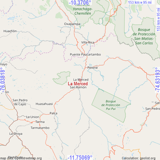
La Merced GPS coordinates[2]
11° 3' 41.256" South, 75° 20' 6.18" West
| Map corner | latitude | longitude |
|---|---|---|
| Upper-left | -10.3706°, | -76.03818° |
| Center: | -11.06146°, | -75.33505° |
| Lower-right: | -11.75069°, | -74.63193° |
| Map W x H: | 153.5×153.5 km | = 95.4×95.4mi |
| max Lat: | -0.96667° ⇑44.7% North |
| La Merced: | -11.06146° |
| min Lat: | ⇓55.3% South -18.01465° |
| min Long | La Merced | max Long |
| -81.30472° | -75.33505° | -69.04167° |
| W 54.8%⇐ | ⇒45.2% E |
Elevation
Elevation of La Merced is 750 m = 2461 ft, and this is 1568.7 m = 5147 ft below average elevation for this country.
| Max E: |
5022 m = 16476 ft | 74.9% |
| Avg. | 2318.7 m = 7607 ft | |
| La Merced | 750 m = 2461 ft | |
Min E: |
1 m = 3 ft | 25.1% |
See also: Peru elevation on elevation.city.
Geographical zone
La Merced is located in South Torrid zone (between Equator and Tropic of Capricorn). Distance of Equator is 1229.9 km =764.2 mi to North.| Distance of | km | miles | from La Merced |
|---|---|---|---|
| Equator | 1229.9 | 764.2 | to North |
| Tropic Capricorn | 1376 | 855 | to South |
| Antarctic Circle | 6171.3 | 3834.7 | to South |
| South Pole | 8777.1 | 5453.8 | to South |


Nearby cities:
15 places around La Merced: (largest is in red/bold)
• Acobamba
48.2 km =30 mi,  227°
227°
• Bajo Pichanaqui
52.5 km =32.6 mi,  73°
73°
• Chontabamba
55.6 km =34.5 mi,  343°
343°
• Huasahuasi
40.9 km =25.4 mi,  236°
236°
• Leticia
57.8 km =35.9 mi, 232°
• Oxapampa
54.3 km =33.7 mi,  352°
352°
• Palca
40.6 km =25.2 mi,  218°
218°
• Palcamayo
54.4 km =33.8 mi, 241°
• Paucartambo
61.1 km =38 mi,  301°
301°
• Perené
17.7 km =11 mi,  43°
43°
• San Pedro de Cajas
61.1 km =38 mi,  249°
249°
• San Ramón
7.4 km =4.6 mi,  199°
199°
• Tapo
44.3 km =27.5 mi,  214°
214°
• Tarma
55.5 km =34.5 mi, 224°
• Villa Rica
36.5 km =22.7 mi,  11°
11°
Sources, notices
• [Note1] Compared only with cities in Peru existing in our database
• [Src1] Map data: © OpenStreetMap contributors (CC-BY-SA)
• [Src2] Other city data from geonames.org with taken over terms of usage.
• [Src3] Geographical zone / Annual Mean Temperature by Robert A. Rohde @ Wikipedia
