Mazamari geodata
Mazamari (Junin) is a seat of a third-order administrative division; located in Peru in America/Lima (GMT-5) time zone. With population of 6,826 people, there are 191 cities with bigger population in this country. Compared to other cities in Peru, 53.6% of cities are located further ↓South; 61.8% of cities are located further ←West and 75.6% of cities have higher elevation than Mazamari. Note1


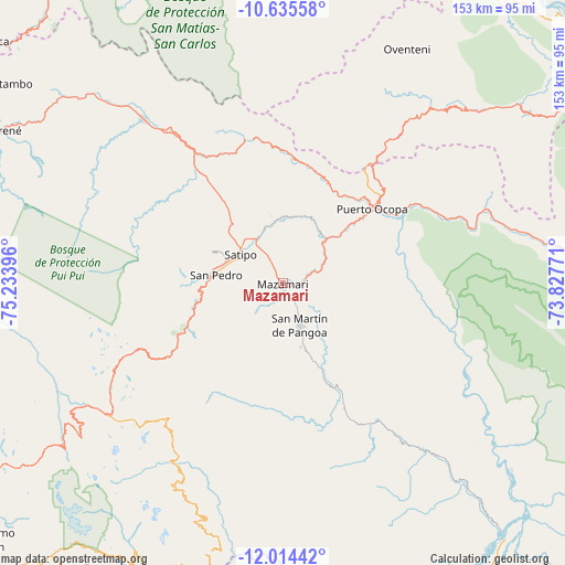
Mazamari GPS coordinates[2]
11° 19' 32.988" South, 74° 31' 50.988" West
| Map corner | latitude | longitude |
|---|---|---|
| Upper-left | -10.63558°, | -75.23396° |
| Center: | -11.32583°, | -74.53083° |
| Lower-right: | -12.01442°, | -73.82771° |
| Map W x H: | 153.3×153.3 km | = 95.3×95.3mi |
| max Lat: | -0.96667° ⇑46.4% North |
| Mazamari: | -11.32583° |
| min Lat: | ⇓53.6% South -18.01465° |
| min Long | Mazamari | max Long |
| -81.30472° | -74.53083° | -69.04167° |
| W 61.8%⇐ | ⇒38.2% E |
Elevation
Elevation of Mazamari is 665 m = 2182 ft, and this is 1653.7 m = 5426 ft below average elevation for this country.
| Max E: |
5022 m = 16476 ft | 75.6% |
| Avg. | 2318.7 m = 7607 ft | |
| Mazamari | 665 m = 2182 ft | |
Min E: |
1 m = 3 ft | 24.4% |
See also: Peru elevation on elevation.city.
Geographical zone
Mazamari is located in South Torrid zone (between Equator and Tropic of Capricorn). Distance of Equator is 1259.3 km =782.5 mi to North.| Distance of | km | miles | from Mazamari |
|---|---|---|---|
| Equator | 1259.3 | 782.5 | to North |
| Tropic Capricorn | 1346.6 | 836.7 | to South |
| Antarctic Circle | 6141.9 | 3816.4 | to South |
| South Pole | 8747.7 | 5435.6 | to South |


Nearby cities:
15 places around Mazamari: (largest is in red/bold)
• Andamarca
54 km =33.6 mi,  213°
213°
• Bajo Pichanaqui
58 km =36 mi,  319°
319°
• Cochas
72.2 km =44.9 mi,  239°
239°
• Comas
74.1 km =46 mi,  234°
234°
• Coviriali
11.2 km =7 mi,  289°
289°
• Ingenio
101.6 km =63.1 mi, 231°
• La Merced
92.5 km =57.5 mi, 288°
• Mariposa
25.5 km =15.8 mi,  250°
250°
• Mucllo
69.1 km =42.9 mi, 242°
• Perené
86.7 km =53.9 mi,  299°
299°
• Puerto Ocopa
31.6 km =19.6 mi,  50°
50°
• Salcabamba
101 km =62.8 mi,  195°
195°
• San Ramón
92.9 km =57.7 mi,  283°
283°
• Satipo
14.3 km =8.9 mi, 304°
• Surcubamba
91.3 km =56.7 mi,  190°
190°
Sources, notices
• [Note1] Compared only with cities in Peru existing in our database
• [Src1] Map data: © OpenStreetMap contributors (CC-BY-SA)
• [Src2] Other city data from geonames.org with taken over terms of usage.
• [Src3] Geographical zone / Annual Mean Temperature by Robert A. Rohde @ Wikipedia
