Satipo geodata
Satipo (Junin) is a seat of a third-order administrative division; located in Peru in America/Lima (GMT-5) time zone. With population of 15,532 people, there are 102 cities with bigger population in this country. Compared to other cities in Peru, 53.9% of cities are located further ↓South; 60.9% of cities are located further ←West and 76.3% of cities have higher elevation than Satipo. Note1


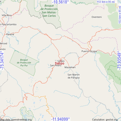
Satipo GPS coordinates[2]
11° 15' 7.992" South, 74° 38' 18.996" West
| Map corner | latitude | longitude |
|---|---|---|
| Upper-left | -10.5618°, | -75.34174° |
| Center: | -11.25222°, | -74.63861° |
| Lower-right: | -11.94099°, | -73.93549° |
| Map W x H: | 153.4×153.4 km | = 95.3×95.3mi |
| max Lat: | -0.96667° ⇑46.1% North |
| Satipo: | -11.25222° |
| min Lat: | ⇓53.9% South -18.01465° |
| min Long | Satipo | max Long |
| -81.30472° | -74.63861° | -69.04167° |
| W 60.9%⇐ | ⇒39.1% E |
Elevation
Elevation of Satipo is 629 m = 2064 ft, and this is 1689.7 m = 5544 ft below average elevation for this country.
| Max E: |
5022 m = 16476 ft | 76.3% |
| Avg. | 2318.7 m = 7607 ft | |
| Satipo | 629 m = 2064 ft | |
Min E: |
1 m = 3 ft | 23.7% |
See also: Peru elevation on elevation.city.
Geographical zone
Satipo is located in South Torrid zone (between Equator and Tropic of Capricorn). Distance of Equator is 1251.1 km =777.4 mi to North.| Distance of | km | miles | from Satipo |
|---|---|---|---|
| Equator | 1251.1 | 777.4 | to North |
| Tropic Capricorn | 1354.8 | 841.8 | to South |
| Antarctic Circle | 6150 | 3821.4 | to South |
| South Pole | 8755.9 | 5440.7 | to South |


Nearby cities:
15 places around Satipo: (largest is in red/bold)
• Andamarca
56.3 km =35 mi,  198°
198°
• Bajo Pichanaqui
44.3 km =27.5 mi,  324°
324°
• Cochas
67.6 km =42 mi,  228°
228°
• Comas
70.7 km =43.9 mi,  222°
222°
• Coviriali
4.6 km =2.9 mi,  164°
164°
• Ingenio
98.4 km =61.1 mi, 223°
• La Merced
78.9 km =49 mi,  285°
285°
• Mariposa
20.7 km =12.9 mi, 216°
• Mazamari
14.3 km =8.9 mi,  124°
124°
• Mucllo
63.8 km =39.6 mi, 230°
• Perené
72.4 km =45 mi,  298°
298°
• Puerto Ocopa
38.1 km =23.7 mi,  72°
72°
• San Ramón
79.7 km =49.5 mi,  280°
280°
• Surcubamba
98.1 km =61 mi,  182°
182°
• Villa Rica
89.4 km =55.6 mi,  309°
309°
Sources, notices
• [Note1] Compared only with cities in Peru existing in our database
• [Src1] Map data: © OpenStreetMap contributors (CC-BY-SA)
• [Src2] Other city data from geonames.org with taken over terms of usage.
• [Src3] Geographical zone / Annual Mean Temperature by Robert A. Rohde @ Wikipedia
