Villanueva geodata
Villanueva (Ilocos) is a section of populated place; located in Philippines in Asia/Manila (GMT+8) time zone. With population of 2,592 people, there are 3123 cities with bigger population in this country. Compared to other cities in Philippines, 84.8% of cities are located further ↓South; 89.7% of cities are located further →East and 57.6% of cities have higher elevation than Villanueva. Note1


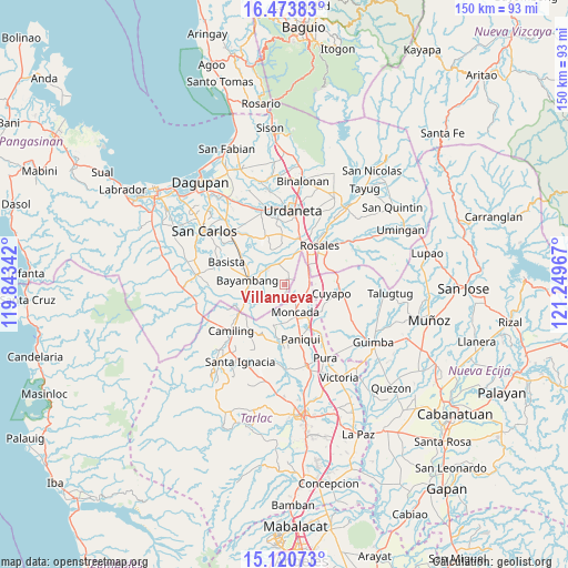
Villanueva GPS coordinates[2]
15° 47' 54.276" North, 120° 32' 47.544" East
| Map corner | latitude | longitude |
|---|---|---|
| Upper-left | 16.47383°, | 119.84342° |
| Center: | 15.79841°, | 120.54654° |
| Lower-right: | 15.12073°, | 121.24967° |
| Map W x H: | 150.5×150.5 km | = 93.5×93.5mi |
| max Lat: | 20.78733° ⇑15.2% North |
| Villanueva: | 15.79841° |
| min Lat: | ⇓84.8% South 4.65442° |
| min Long | Villanueva | max Long |
| 117.04868° | 120.54654° | 126.58417° |
| W 10.3%⇐ | ⇒89.7% E |
Elevation
Elevation of Villanueva is 18 m = 59 ft, and this is 69.9 m = 229 ft below average elevation for this country.
| Max E: |
2262 m = 7421 ft | 57.6% |
| Avg. | 87.9 m = 288 ft | |
| Villanueva | 18 m = 59 ft | |
Min E: |
-2 m = -7 ft | 42.4% |
See also: Philippines elevation on elevation.city.
Geographical zone
Villanueva is located in North Torrid zone (between Equator and Tropic of Cancer). Distance of this Northern Tropic circle is 849.3 km =527.7 mi to North.| Distance of | km | miles | from Villanueva |
|---|---|---|---|
| North Pole | 8250.4 | 5126.6 | to North |
| Arctic Circle | 5644.6 | 3507.4 | to North |
| Tropic Cancer | 849.3 | 527.7 | to North |
| Equator | 1756.6 | 1091.5 | to South |


Nearby cities:
15 places around Villanueva: (largest is in red/bold)
• Alcala
5.9 km =3.7 mi,  336°
336°
• Anulid
6.9 km =4.3 mi,  295°
295°
• Barangobong
8.8 km =5.5 mi,  1°
1°
• Bautista
5.4 km =3.4 mi,  252°
252°
• Buenlag
5.1 km =3.2 mi,  312°
312°
• Burgos
8.2 km =5.1 mi,  160°
160°
• Guiling
8.9 km =5.5 mi,  55°
55°
• Lanat
6.3 km =3.9 mi,  96°
96°
• Moncada
7.6 km =4.7 mi, 157°
• Olea
9.1 km =5.7 mi,  321°
321°
• Pindangan Centro
6.9 km =4.3 mi, 4°
• Salcedo
8.7 km =5.4 mi,  41°
41°
• San Felipe
6.3 km =3.9 mi, 60°
• San Manuel
6.6 km =4.1 mi,  89°
89°
• San Pedro Apartado
4.7 km =2.9 mi,  24°
24°
Sources, notices
• [Note1] Compared only with cities in Philippines existing in our database
• [Src1] Map data: © OpenStreetMap contributors (CC-BY-SA)
• [Src2] Other city data from geonames.org with taken over terms of usage.
• [Src3] Geographical zone / Annual Mean Temperature by Robert A. Rohde @ Wikipedia
