Anulid geodata
Anulid (Ilocos) is a populated place; located in Philippines in Asia/Manila (GMT+8) time zone. With population of 2,177 people, there are 3934 cities with bigger population in this country. Compared to other cities in Philippines, 85.1% of cities are located further ↓South; 91% of cities are located further →East and 53.5% of cities have lower elevation than Anulid. Note1


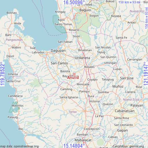
Anulid GPS coordinates[2]
15° 49' 32.268" North, 120° 29' 18.024" East
| Map corner | latitude | longitude |
|---|---|---|
| Upper-left | 16.50096°, | 119.78522° |
| Center: | 15.82563°, | 120.48834° |
| Lower-right: | 15.14804°, | 121.19147° |
| Map W x H: | 150.4×150.4 km | = 93.5×93.5mi |
| max Lat: | 20.78733° ⇑14.9% North |
| Anulid: | 15.82563° |
| min Lat: | ⇓85.1% South 4.65442° |
| min Long | Anulid | max Long |
| 117.04868° | 120.48834° | 126.58417° |
| W 9%⇐ | ⇒91% E |
Elevation
Elevation of Anulid is 26 m = 85 ft, and this is 61.9 m = 203 ft below average elevation for this country.
| Max E: |
2262 m = 7421 ft | 46.5% |
| Avg. | 87.9 m = 288 ft | |
| Anulid | 26 m = 85 ft | |
Min E: |
-2 m = -7 ft | 53.5% |
See also: Philippines elevation on elevation.city.
Geographical zone
Anulid is located in North Torrid zone (between Equator and Tropic of Cancer). Distance of this Northern Tropic circle is 846.3 km =525.9 mi to North.| Distance of | km | miles | from Anulid |
|---|---|---|---|
| North Pole | 8247.4 | 5124.7 | to North |
| Arctic Circle | 5641.5 | 3505.5 | to North |
| Tropic Cancer | 846.3 | 525.9 | to North |
| Equator | 1759.6 | 1093.4 | to South |


Nearby cities:
15 places around Anulid: (largest is in red/bold)
• Alcala
4.5 km =2.8 mi,  57°
57°
• Baluyot
4.4 km =2.7 mi,  221°
221°
• Bautista
4.8 km =3 mi,  166°
166°
• Bayambang
3.8 km =2.4 mi,  247°
247°
• Bical Norte
5.8 km =3.6 mi,  257°
257°
• Buenlag
2.5 km =1.6 mi,  79°
79°
• Lepa
7.7 km =4.8 mi,  328°
328°
• Nalsian Norte
4.5 km =2.8 mi,  297°
297°
• Olea
4.1 km =2.5 mi,  7°
7°
• Pindangan Centro
7.8 km =4.8 mi, 60°
• San Gabriel First
7.4 km =4.6 mi,  207°
207°
• San Pedro Apartado
8.3 km =5.2 mi, 81°
• Tanolong
8.3 km =5.2 mi, 253°
• Tococ East
6.7 km =4.2 mi,  269°
269°
• Villanueva
6.9 km =4.3 mi,  115°
115°
Sources, notices
• [Note1] Compared only with cities in Philippines existing in our database
• [Src1] Map data: © OpenStreetMap contributors (CC-BY-SA)
• [Src2] Other city data from geonames.org with taken over terms of usage.
• [Src3] Geographical zone / Annual Mean Temperature by Robert A. Rohde @ Wikipedia
