Malandag geodata
Malandag (Soccsksargen) is a populated place; located in Philippines in Asia/Manila (GMT+8) time zone. With population of 12,867 people, there are 497 cities with bigger population in this country. Compared to other cities in Philippines, 96.6% of cities are located further ↑North; 90.7% of cities are located further ←West and 88.7% of cities have lower elevation than Malandag. Note1


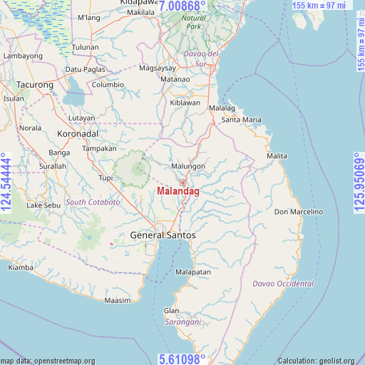
Malandag GPS coordinates[2]
6° 18' 37.08" North, 125° 14' 51.216" East
| Map corner | latitude | longitude |
|---|---|---|
| Upper-left | 7.00868°, | 124.54444° |
| Center: | 6.3103°, | 125.24756° |
| Lower-right: | 5.61098°, | 125.95069° |
| Map W x H: | 155.4×155.4 km | = 96.6×96.6mi |
| max Lat: | 20.78733° ⇑96.6% North |
| Malandag: | 6.3103° |
| min Lat: | ⇓3.4% South 4.65442° |
| min Long | Malandag | max Long |
| 117.04868° | 125.24756° | 126.58417° |
| W 90.7%⇐ | ⇒9.3% E |
Elevation
Elevation of Malandag is 198 m = 650 ft, and this is 110.1 m = 361 ft above average elevation for this country.
| Max E: |
2262 m = 7421 ft | 11.3% |
| Malandag | 198 m 650 ft | |
| Avg. | 87.9 m = 288 ft | |
Min E: |
-2 m = -7 ft | 88.7% |
See also: Philippines elevation on elevation.city.
Geographical zone
Malandag is located in North Torrid zone (between Equator and Tropic of Cancer). Distance of Equator is 701.6 km =436 mi to South.| Distance of | km | miles | from Malandag |
|---|---|---|---|
| North Pole | 9305.4 | 5782.1 | to North |
| Arctic Circle | 6699.5 | 4162.9 | to North |
| Tropic Cancer | 1904.3 | 1183.3 | to North |
| Equator | 701.6 | 436 | to South |


Nearby cities:
15 places around Malandag: (largest is in red/bold)
• Alabel
23.7 km =14.7 mi,  168°
168°
• Batutitik
9.7 km =6 mi,  177°
177°
• Buayan
21.6 km =13.4 mi, 183°
• Conel
13.7 km =8.5 mi,  209°
209°
• General Santos
23.5 km =14.6 mi,  200°
200°
• Katangawan
15.6 km =9.7 mi,  190°
190°
• Klinan
18.4 km =11.4 mi,  221°
221°
• Maluñgun
5.1 km =3.2 mi,  132°
132°
• Manga
7.1 km =4.4 mi,  107°
107°
• Palkan
23.9 km =14.9 mi,  266°
266°
• Polo
15.8 km =9.8 mi,  251°
251°
• Polomolok
22.6 km =14 mi,  244°
244°
• Silway 7
20.4 km =12.7 mi, 223°
• Tinagacan
12.5 km =7.8 mi, 189°
• Upper Klinan
16.8 km =10.4 mi, 236°
Sources, notices
• [Note1] Compared only with cities in Philippines existing in our database
• [Src1] Map data: © OpenStreetMap contributors (CC-BY-SA)
• [Src2] Other city data from geonames.org with taken over terms of usage.
• [Src3] Geographical zone / Annual Mean Temperature by Robert A. Rohde @ Wikipedia
