Cuyapo geodata
Cuyapo (Central Luzon) is a seat of a third-order administrative division; located in Philippines in Asia/Manila (GMT+8) time zone. With population of 8,595 people, there are 724 cities with bigger population in this country. Compared to other cities in Philippines, 84.6% of cities are located further ↓South; 85.9% of cities are located further →East and 60.3% of cities have lower elevation than Cuyapo. Note1


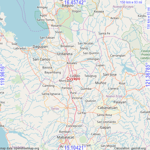
Cuyapo GPS coordinates[2]
15° 46' 54.984" North, 120° 39' 52.992" East
| Map corner | latitude | longitude |
|---|---|---|
| Upper-left | 16.45742°, | 119.9616° |
| Center: | 15.78194°, | 120.66472° |
| Lower-right: | 15.10421°, | 121.36785° |
| Map W x H: | 150.5×150.5 km | = 93.5×93.5mi |
| max Lat: | 20.78733° ⇑15.4% North |
| Cuyapo: | 15.78194° |
| min Lat: | ⇓84.6% South 4.65442° |
| min Long | Cuyapo | max Long |
| 117.04868° | 120.66472° | 126.58417° |
| W 14.1%⇐ | ⇒85.9% E |
Elevation
Elevation of Cuyapo is 34 m = 112 ft, and this is 53.9 m = 177 ft below average elevation for this country.
| Max E: |
2262 m = 7421 ft | 39.7% |
| Avg. | 87.9 m = 288 ft | |
| Cuyapo | 34 m = 112 ft | |
Min E: |
-2 m = -7 ft | 60.3% |
See also: Philippines elevation on elevation.city.
Geographical zone
Cuyapo is located in North Torrid zone (between Equator and Tropic of Cancer). Distance of this Northern Tropic circle is 851.1 km =528.8 mi to North.| Distance of | km | miles | from Cuyapo |
|---|---|---|---|
| North Pole | 8252.3 | 5127.7 | to North |
| Arctic Circle | 5646.4 | 3508.5 | to North |
| Tropic Cancer | 851.1 | 528.8 | to North |
| Equator | 1754.8 | 1090.4 | to South |


Nearby cities:
15 places around Cuyapo: (largest is in red/bold)
• Anao
7.2 km =4.5 mi,  215°
215°
• Bued
6.3 km =3.9 mi,  345°
345°
• Burgos
11.5 km =7.1 mi,  239°
239°
• Calancuasan Norte
3.3 km =2.1 mi,  310°
310°
• Esmeralda
10.9 km =6.8 mi,  29°
29°
• Estacion
11 km =6.8 mi,  213°
213°
• Guiling
8.6 km =5.3 mi,  321°
321°
• Lanat
6.5 km =4 mi,  279°
279°
• Moncada
11 km =6.8 mi, 241°
• Nampicuan
7 km =4.3 mi, 217°
• Paitan Norte
10 km =6.2 mi,  54°
54°
• Pance
11.4 km =7.1 mi,  204°
204°
• Salcedo
10.9 km =6.8 mi, 320°
• San Felipe
8.7 km =5.4 mi,  304°
304°
• San Manuel
6.3 km =3.9 mi,  287°
287°
Sources, notices
• [Note1] Compared only with cities in Philippines existing in our database
• [Src1] Map data: © OpenStreetMap contributors (CC-BY-SA)
• [Src2] Other city data from geonames.org with taken over terms of usage.
• [Src3] Geographical zone / Annual Mean Temperature by Robert A. Rohde @ Wikipedia
