Kabirwala geodata
Kabirwala (Punjab) is a populated place; located in Pakistan in Asia/Karachi (GMT+5) time zone. With population of 60,782 people, there are 118 cities with bigger population in this country. Compared to other cities in Pakistan, 55.1% of cities are located further ↑North; 54.6% of cities are located further ←West and 62.8% of cities have higher elevation than Kabirwala. Note1


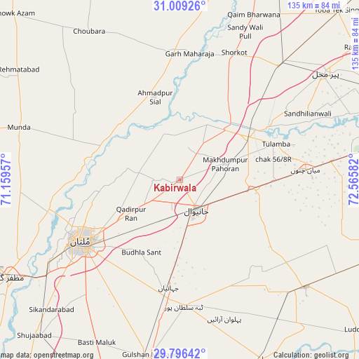
Kabirwala GPS coordinates[2]
30° 24' 16.992" North, 71° 51' 45.684" East
| Map corner | latitude | longitude |
|---|---|---|
| Upper-left | 31.00926°, | 71.15957° |
| Center: | 30.40472°, | 71.86269° |
| Lower-right: | 29.79642°, | 72.56582° |
| Map W x H: | 134.9×134.9 km | = 83.8×83.8mi |
| max Lat: | 36.32162° ⇑55.1% North |
| Kabirwala: | 30.40472° |
| min Lat: | ⇓44.9% South 24.14422° |
| min Long | Kabirwala | max Long |
| 61.74573° | 71.86269° | 75.63372° |
| W 54.6%⇐ | ⇒45.4% E |
Elevation
Elevation of Kabirwala is 138 m = 453 ft, and this is 207 m = 679 ft below average elevation for this country.
| Max E: |
2732 m = 8963 ft | 62.8% |
| Avg. | 345 m = 1132 ft | |
| Kabirwala | 138 m = 453 ft | |
Min E: |
3 m = 10 ft | 37.2% |
See also: Kabirwala elevation on elevation.city.
Geographical zone
Kabirwala is located in North temperate zone (between Tropic of Cancer and the Arctic Circle). Distance of this Northern Tropic circle is 774.8 km =481.4 mi to South.| Distance of | km | miles | from Kabirwala |
|---|---|---|---|
| North Pole | 6626.4 | 4117.5 | to North |
| Arctic Circle | 4020.5 | 2498.2 | to North |
| Tropic Cancer | 774.8 | 481.4 | to South |
| Equator | 3380.7 | 2100.7 | to South |


Nearby cities:
15 places around Kabirwala: (largest is in red/bold)
• Ahmadpur Sial
32.5 km =20.2 mi,  339°
339°
• Chak Thirty-one -Eleven Left
80.1 km =49.8 mi,  88°
88°
• Dunyapur
67.9 km =42.2 mi,  189°
189°
• Garh Maharaja
47.9 km =29.8 mi,  4°
4°
• Khanewal
13.2 km =8.2 mi,  149°
149°
• Mailsi
73.5 km =45.7 mi,  155°
155°
• Mian Channun
47.5 km =29.5 mi, 85°
• Multan
43.6 km =27.1 mi,  237°
237°
• Muzaffargarh
74.1 km =46 mi, 240°
• Pir Mahal
67.9 km =42.2 mi,  53°
53°
• Qadirpur Ran
22.2 km =13.8 mi, 235°
• Sarai Sidhu
23.5 km =14.6 mi,  25°
25°
• Shujaabad
79.9 km =49.6 mi,  223°
223°
• Talamba
38.7 km =24 mi,  69°
69°
• Vihari
62 km =38.5 mi,  130°
130°
Sources, notices
• [Note1] Compared only with cities in Pakistan existing in our database
• [Src1] Map data: © OpenStreetMap contributors (CC-BY-SA)
• [Src2] Other city data from geonames.org with taken over terms of usage.
• [Src3] Geographical zone / Annual Mean Temperature by Robert A. Rohde @ Wikipedia
