Sarai Sidhu geodata
Sarai Sidhu (Punjab) is a populated place; located in Pakistan in Asia/Karachi (GMT+5) time zone. With population of 15,632 people, there are 310 cities with bigger population in this country. Compared to other cities in Pakistan, 52.1% of cities are located further ↑North; 56.7% of cities are located further ←West and 60.9% of cities have higher elevation than Sarai Sidhu. Note1


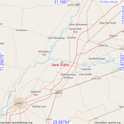
Sarai Sidhu GPS coordinates[2]
30° 35' 41.136" North, 71° 58' 11.64" East
| Map corner | latitude | longitude |
|---|---|---|
| Upper-left | 31.1981°, | 71.26678° |
| Center: | 30.59476°, | 71.9699° |
| Lower-right: | 29.98764°, | 72.67303° |
| Map W x H: | 134.6×134.6 km | = 83.6×83.6mi |
| max Lat: | 36.32162° ⇑52.1% North |
| Sarai Sidhu: | 30.59476° |
| min Lat: | ⇓47.9% South 24.14422° |
| min Long | Sarai Sidhu | max Long |
| 61.74573° | 71.9699° | 75.63372° |
| W 56.7%⇐ | ⇒43.3% E |
Elevation
Elevation of Sarai Sidhu is 143 m = 469 ft, and this is 202 m = 663 ft below average elevation for this country.
| Max E: |
2732 m = 8963 ft | 60.9% |
| Avg. | 345 m = 1132 ft | |
| Sarai Sidhu | 143 m = 469 ft | |
Min E: |
3 m = 10 ft | 39.1% |
See also: Pakistan elevation on elevation.city.
Geographical zone
Sarai Sidhu is located in North temperate zone (between Tropic of Cancer and the Arctic Circle). Distance of this Northern Tropic circle is 795.9 km =494.5 mi to South.| Distance of | km | miles | from Sarai Sidhu |
|---|---|---|---|
| North Pole | 6605.2 | 4104.3 | to North |
| Arctic Circle | 3999.4 | 2485.1 | to North |
| Tropic Cancer | 795.9 | 494.5 | to South |
| Equator | 3401.8 | 2113.8 | to South |


Nearby cities:
15 places around Sarai Sidhu: (largest is in red/bold)
• Ahmadpur Sial
23.6 km =14.7 mi,  293°
293°
• Būrewāla
80.8 km =50.2 mi,  126°
126°
• Chak Thirty-one -Eleven Left
72.2 km =44.9 mi,  105°
105°
• Chichawatni
69.5 km =43.2 mi,  95°
95°
• Garh Maharaja
27.3 km =17 mi,  346°
346°
• Kabirwala
23.5 km =14.6 mi,  205°
205°
• Kamalia
66.3 km =41.2 mi,  77°
77°
• Khanewal
32.8 km =20.4 mi,  186°
186°
• Mian Channun
40.8 km =25.4 mi, 114°
• Multan
64.7 km =40.2 mi,  226°
226°
• Pir Mahal
48.4 km =30.1 mi,  66°
66°
• Qadirpur Ran
44.2 km =27.5 mi,  220°
220°
• Talamba
27 km =16.8 mi, 106°
• Toba Tek Singh
64.4 km =40 mi,  49°
49°
• Vihari
71.5 km =44.4 mi,  148°
148°
Sources, notices
• [Note1] Compared only with cities in Pakistan existing in our database
• [Src1] Map data: © OpenStreetMap contributors (CC-BY-SA)
• [Src2] Other city data from geonames.org with taken over terms of usage.
• [Src3] Geographical zone / Annual Mean Temperature by Robert A. Rohde @ Wikipedia
