Kahror Pakka geodata
Kahror Pakka (Punjab) is a populated place; located in Pakistan in Asia/Karachi (GMT+5) time zone. With population of 69,743 people, there are 97 cities with bigger population in this country. Compared to other cities in Pakistan, 62.1% of cities are located further ↑North; 55.5% of cities are located further ←West and 64.1% of cities have higher elevation than Kahror Pakka. Note1


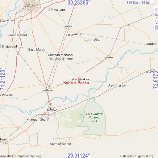
Kahror Pakka GPS coordinates[2]
29° 37' 27.48" North, 71° 54' 51.732" East
| Map corner | latitude | longitude |
|---|---|---|
| Upper-left | 30.23365°, | 71.21125° |
| Center: | 29.6243°, | 71.91437° |
| Lower-right: | 29.01124°, | 72.6175° |
| Map W x H: | 135.9×135.9 km | = 84.4×84.4mi |
| max Lat: | 36.32162° ⇑62.1% North |
| Kahror Pakka: | 29.6243° |
| min Lat: | ⇓37.9% South 24.14422° |
| min Long | Kahror Pakka | max Long |
| 61.74573° | 71.91437° | 75.63372° |
| W 55.5%⇐ | ⇒44.5% E |
Elevation
Elevation of Kahror Pakka is 132 m = 433 ft, and this is 213 m = 699 ft below average elevation for this country.
| Max E: |
2732 m = 8963 ft | 64.1% |
| Avg. | 345 m = 1132 ft | |
| Kahror Pakka | 132 m = 433 ft | |
Min E: |
3 m = 10 ft | 35.9% |
See also: Kahror Pakka elevation on elevation.city.
Geographical zone
Kahror Pakka is located in North temperate zone (between Tropic of Cancer and the Arctic Circle). Distance of this Northern Tropic circle is 688 km =427.5 mi to South.| Distance of | km | miles | from Kahror Pakka |
|---|---|---|---|
| North Pole | 6713.1 | 4171.3 | to North |
| Arctic Circle | 4107.3 | 2552.2 | to North |
| Tropic Cancer | 688 | 427.5 | to South |
| Equator | 3293.9 | 2046.7 | to South |


Nearby cities:
15 places around Kahror Pakka: (largest is in red/bold)
• Bahawalpur
34.2 km =21.3 mi,  222°
222°
• Dhanot
16.4 km =10.2 mi,  252°
252°
• Dunyapur
25.8 km =16 mi,  320°
320°
• Hasilpur
61.5 km =38.2 mi,  82°
82°
• Jalalpur Pirwala
68.3 km =42.4 mi,  258°
258°
• Khairpur Tamewah
31.7 km =19.7 mi,  98°
98°
• Khanewal
75.3 km =46.8 mi,  1°
1°
• Khangarh
79.6 km =49.5 mi,  293°
293°
• Lodhran
29.1 km =18.1 mi, 249°
• Mailsi
31.9 km =19.8 mi,  51°
51°
• Multan
76.3 km =47.4 mi,  326°
326°
• Qadirpur Ran
77.8 km =48.3 mi,  342°
342°
• Shujaabad
66.4 km =41.3 mi,  295°
295°
• Vihari
63.2 km =39.3 mi,  42°
42°
• Yazman
58.3 km =36.2 mi,  196°
196°
Sources, notices
• [Note1] Compared only with cities in Pakistan existing in our database
• [Src1] Map data: © OpenStreetMap contributors (CC-BY-SA)
• [Src2] Other city data from geonames.org with taken over terms of usage.
• [Src3] Geographical zone / Annual Mean Temperature by Robert A. Rohde @ Wikipedia
