Qadirpur Ran geodata
Qadirpur Ran (Punjab) is a populated place; located in Pakistan in Asia/Karachi (GMT+5) time zone. With population of 20,407 people, there are 269 cities with bigger population in this country. Compared to other cities in Pakistan, 56.2% of cities are located further ↑North; 52.1% of cities are located further ←West and 64.3% of cities have higher elevation than Qadirpur Ran. Note1


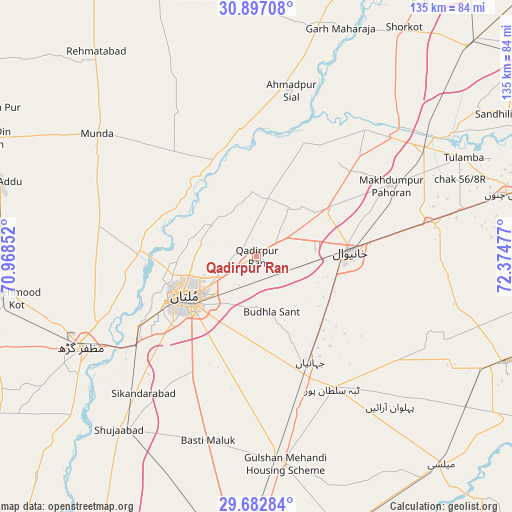
Qadirpur Ran GPS coordinates[2]
30° 17' 30.624" North, 71° 40' 17.904" East
| Map corner | latitude | longitude |
|---|---|---|
| Upper-left | 30.89708°, | 70.96852° |
| Center: | 30.29184°, | 71.67164° |
| Lower-right: | 29.68284°, | 72.37477° |
| Map W x H: | 135×135 km | = 83.9×83.9mi |
| max Lat: | 36.32162° ⇑56.2% North |
| Qadirpur Ran: | 30.29184° |
| min Lat: | ⇓43.8% South 24.14422° |
| min Long | Qadirpur Ran | max Long |
| 61.74573° | 71.67164° | 75.63372° |
| W 52.1%⇐ | ⇒47.9% E |
Elevation
Elevation of Qadirpur Ran is 131 m = 430 ft, and this is 214 m = 702 ft below average elevation for this country.
| Max E: |
2732 m = 8963 ft | 64.3% |
| Avg. | 345 m = 1132 ft | |
| Qadirpur Ran | 131 m = 430 ft | |
Min E: |
3 m = 10 ft | 35.7% |
See also: Pakistan elevation on elevation.city.
Geographical zone
Qadirpur Ran is located in North temperate zone (between Tropic of Cancer and the Arctic Circle). Distance of this Northern Tropic circle is 762.2 km =473.6 mi to South.| Distance of | km | miles | from Qadirpur Ran |
|---|---|---|---|
| North Pole | 6638.9 | 4125.2 | to North |
| Arctic Circle | 4033 | 2506 | to North |
| Tropic Cancer | 762.2 | 473.6 | to South |
| Equator | 3368.1 | 2092.8 | to South |


Nearby cities:
15 places around Qadirpur Ran: (largest is in red/bold)
• Ahmadpur Sial
43.5 km =27 mi,  9°
9°
• Dunyapur
54.8 km =34.1 mi,  172°
172°
• Garh Maharaja
64.3 km =40 mi,  20°
20°
• Kabirwala
22.2 km =13.8 mi,  55°
55°
• Khanewal
25 km =15.5 mi,  87°
87°
• Khangarh
64.6 km =40.1 mi,  229°
229°
• Kot Addu
70.4 km =43.7 mi,  286°
286°
• Mailsi
72.9 km =45.3 mi,  138°
138°
• Mian Channun
67.8 km =42.1 mi,  75°
75°
• Multan
21.4 km =13.3 mi,  240°
240°
• Muzaffargarh
52 km =32.3 mi, 242°
• Sarai Sidhu
44.2 km =27.5 mi,  40°
40°
• Shujaabad
58.4 km =36.3 mi,  218°
218°
• Talamba
60.5 km =37.6 mi, 64°
• Vihari
71.3 km =44.3 mi,  112°
112°
Sources, notices
• [Note1] Compared only with cities in Pakistan existing in our database
• [Src1] Map data: © OpenStreetMap contributors (CC-BY-SA)
• [Src2] Other city data from geonames.org with taken over terms of usage.
• [Src3] Geographical zone / Annual Mean Temperature by Robert A. Rohde @ Wikipedia
