Dunyapur geodata
Dunyapur (Punjab) is a populated place; located in Pakistan in Asia/Karachi (GMT+5) time zone. With population of 34,044 people, there are 186 cities with bigger population in this country. Compared to other cities in Pakistan, 60.3% of cities are located further ↑North; 52.8% of cities are located further ←West and 65.5% of cities have higher elevation than Dunyapur. Note1


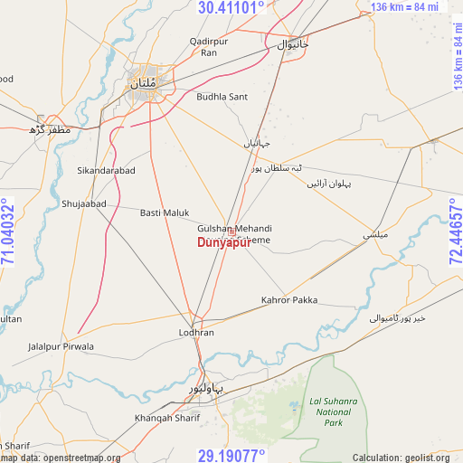
Dunyapur GPS coordinates[2]
29° 48' 9.9" North, 71° 44' 36.384" East
| Map corner | latitude | longitude |
|---|---|---|
| Upper-left | 30.41101°, | 71.04032° |
| Center: | 29.80275°, | 71.74344° |
| Lower-right: | 29.19077°, | 72.44657° |
| Map W x H: | 135.7×135.7 km | = 84.3×84.3mi |
| max Lat: | 36.32162° ⇑60.3% North |
| Dunyapur: | 29.80275° |
| min Lat: | ⇓39.7% South 24.14422° |
| min Long | Dunyapur | max Long |
| 61.74573° | 71.74344° | 75.63372° |
| W 52.8%⇐ | ⇒47.2% E |
Elevation
Elevation of Dunyapur is 122 m = 400 ft, and this is 223 m = 732 ft below average elevation for this country.
| Max E: |
2732 m = 8963 ft | 65.5% |
| Avg. | 345 m = 1132 ft | |
| Dunyapur | 122 m = 400 ft | |
Min E: |
3 m = 10 ft | 34.5% |
See also: Pakistan elevation on elevation.city.
Geographical zone
Dunyapur is located in North temperate zone (between Tropic of Cancer and the Arctic Circle). Distance of this Northern Tropic circle is 707.8 km =439.8 mi to South.| Distance of | km | miles | from Dunyapur |
|---|---|---|---|
| North Pole | 6693.3 | 4159 | to North |
| Arctic Circle | 4087.4 | 2539.8 | to North |
| Tropic Cancer | 707.8 | 439.8 | to South |
| Equator | 3313.8 | 2059.1 | to South |


Nearby cities:
15 places around Dunyapur: (largest is in red/bold)
• Bahawalpur
45.5 km =28.3 mi,  188°
188°
• Dhanot
24.8 km =15.4 mi,  178°
178°
• Jalalpur Pirwala
60.3 km =37.5 mi,  236°
236°
• Kabirwala
67.9 km =42.2 mi,  9°
9°
• Kahror Pakka
25.8 km =16 mi,  140°
140°
• Khairpur Tamewah
53.7 km =33.4 mi,  117°
117°
• Khanewal
58.4 km =36.3 mi,  18°
18°
• Khangarh
57.6 km =35.8 mi,  282°
282°
• Lodhran
31.8 km =19.8 mi,  199°
199°
• Mailsi
41.5 km =25.8 mi,  90°
90°
• Multan
50.7 km =31.5 mi,  329°
329°
• Muzaffargarh
60.9 km =37.8 mi,  299°
299°
• Qadirpur Ran
54.8 km =34.1 mi,  352°
352°
• Shujaabad
44.3 km =27.5 mi, 281°
• Vihari
64.8 km =40.3 mi,  65°
65°
Sources, notices
• [Note1] Compared only with cities in Pakistan existing in our database
• [Src1] Map data: © OpenStreetMap contributors (CC-BY-SA)
• [Src2] Other city data from geonames.org with taken over terms of usage.
• [Src3] Geographical zone / Annual Mean Temperature by Robert A. Rohde @ Wikipedia
