Shakargarh geodata
Shakargarh (Punjab) is a populated place; located in Pakistan in Asia/Karachi (GMT+5) time zone. With population of 64,304 people, there are 111 cities with bigger population in this country. Compared to other cities in Pakistan, 70.2% of cities are located further ↓South; 99.8% of cities are located further ←West and 72.9% of cities have lower elevation than Shakargarh. Note1


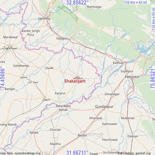
Shakargarh GPS coordinates[2]
32° 15' 48.996" North, 75° 9' 36.288" East
| Map corner | latitude | longitude |
|---|---|---|
| Upper-left | 32.85622°, | 74.45696° |
| Center: | 32.26361°, | 75.16008° |
| Lower-right: | 31.66711°, | 75.86321° |
| Map W x H: | 132.2×132.2 km | = 82.1×82.1mi |
| max Lat: | 36.32162° ⇑29.8% North |
| Shakargarh: | 32.26361° |
| min Lat: | ⇓70.2% South 24.14422° |
| min Long | Shakargarh | max Long |
| 61.74573° | 75.16008° | 75.63372° |
| W 99.8%⇐ | ⇒0.2% E |
Elevation
Elevation of Shakargarh is 266 m = 873 ft, and this is 79 m = 259 ft below average elevation for this country.
| Max E: |
2732 m = 8963 ft | 27.1% |
| Avg. | 345 m = 1132 ft | |
| Shakargarh | 266 m = 873 ft | |
Min E: |
3 m = 10 ft | 72.9% |
See also: Shakargarh elevation on elevation.city.
Geographical zone
Shakargarh is located in North temperate zone (between Tropic of Cancer and the Arctic Circle). Distance of this Northern Tropic circle is 981.5 km =609.9 mi to South.| Distance of | km | miles | from Shakargarh |
|---|---|---|---|
| North Pole | 6419.7 | 3989 | to North |
| Arctic Circle | 3813.8 | 2369.8 | to North |
| Tropic Cancer | 981.5 | 609.9 | to South |
| Equator | 3587.4 | 2229.1 | to South |


Nearby cities:
15 places around Shakargarh: (largest is in red/bold)
• Baddomalhi
55.7 km =34.6 mi,  236°
236°
• Bhopalwala
77.1 km =47.9 mi,  283°
283°
• Chawinda
43.7 km =27.2 mi, 281°
• Daska Kalan
76.4 km =47.5 mi, 275°
• Fazilpur
13.1 km =8.1 mi,  222°
222°
• Hadali
69.5 km =43.2 mi,  307°
307°
• Kalaswala
48.6 km =30.2 mi,  261°
261°
• Kot Ghulam Muhammad
58.1 km =36.1 mi, 277°
• Kot Rajkour
52.6 km =32.7 mi,  288°
288°
• Kotli Loharan
72.2 km =44.9 mi,  300°
300°
• Narang Mandi
72.7 km =45.2 mi, 236°
• Narowal
32.4 km =20.1 mi, 236°
• Pasrur
46.7 km =29 mi,  269°
269°
• Sialkot
64.3 km =40 mi, 293°
• Zafarwal
26.1 km =16.2 mi, 290°
Sources, notices
• [Note1] Compared only with cities in Pakistan existing in our database
• [Src1] Map data: © OpenStreetMap contributors (CC-BY-SA)
• [Src2] Other city data from geonames.org with taken over terms of usage.
• [Src3] Geographical zone / Annual Mean Temperature by Robert A. Rohde @ Wikipedia
