Garhi Khairo geodata
Garhi Khairo (Balochistan) is a populated place; located in Pakistan in Asia/Karachi (GMT+5) time zone. With population of 13,666 people, there are 328 cities with bigger population in this country. Compared to other cities in Pakistan, 72.2% of cities are located further ↑North; 88.3% of cities are located further →East and 81.9% of cities have higher elevation than Garhi Khairo. Note1


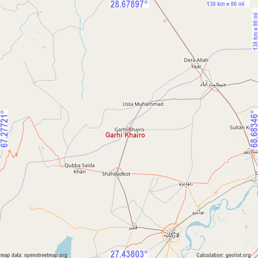
Garhi Khairo GPS coordinates[2]
28° 3' 37.044" North, 67° 58' 49.188" East
| Map corner | latitude | longitude |
|---|---|---|
| Upper-left | 28.67897°, | 67.27721° |
| Center: | 28.06029°, | 67.98033° |
| Lower-right: | 27.43803°, | 68.68346° |
| Map W x H: | 138×138 km | = 85.7×85.7mi |
| max Lat: | 36.32162° ⇑72.2% North |
| Garhi Khairo: | 28.06029° |
| min Lat: | ⇓27.8% South 24.14422° |
| min Long | Garhi Khairo | max Long |
| 61.74573° | 67.98033° | 75.63372° |
| W 11.7%⇐ | ⇒88.3% E |
Elevation
Elevation of Garhi Khairo is 51 m = 167 ft, and this is 294 m = 965 ft below average elevation for this country.
| Max E: |
2732 m = 8963 ft | 81.9% |
| Avg. | 345 m = 1132 ft | |
| Garhi Khairo | 51 m = 167 ft | |
Min E: |
3 m = 10 ft | 18.1% |
See also: Pakistan elevation on elevation.city.
Geographical zone
Garhi Khairo is located in North temperate zone (between Tropic of Cancer and the Arctic Circle). Distance of this Northern Tropic circle is 514.1 km =319.4 mi to South.| Distance of | km | miles | from Garhi Khairo |
|---|---|---|---|
| North Pole | 6887.1 | 4279.4 | to North |
| Arctic Circle | 4281.2 | 2660.2 | to North |
| Tropic Cancer | 514.1 | 319.4 | to South |
| Equator | 3120 | 1938.7 | to South |


Nearby cities:
15 places around Garhi Khairo: (largest is in red/bold)
• Chowki Jamali
7.4 km =4.6 mi,  232°
232°
• Dera Allahyar
50.3 km =31.3 mi,  46°
46°
• Dera Murad Jamali
59.1 km =36.7 mi,  23°
23°
• Garhiyasin
54.9 km =34.1 mi,  108°
108°
• Jacobabad
51.1 km =31.8 mi,  61°
61°
• Kambar
52.6 km =32.7 mi,  177°
177°
• Larkana
60.2 km =37.4 mi,  157°
157°
• Madeji
57.5 km =35.7 mi,  126°
126°
• Mehrabpur
6.9 km =4.3 mi,  40°
40°
• Miro Khan
35.2 km =21.9 mi, 161°
• Naudero
57.6 km =35.8 mi,  139°
139°
• Ratodero
41.7 km =25.9 mi, 133°
• Shahdad Kot
24.8 km =15.4 mi,  196°
196°
• Shikarpur
65.6 km =40.8 mi,  100°
100°
• Usta Muhammad
14.4 km =8.9 mi,  25°
25°
Sources, notices
• [Note1] Compared only with cities in Pakistan existing in our database
• [Src1] Map data: © OpenStreetMap contributors (CC-BY-SA)
• [Src2] Other city data from geonames.org with taken over terms of usage.
• [Src3] Geographical zone / Annual Mean Temperature by Robert A. Rohde @ Wikipedia
