Mehrabpur geodata
Mehrabpur (Balochistan) is a populated place; located in Pakistan in Asia/Karachi (GMT+5) time zone. With population of 35,263 people, there are 178 cities with bigger population in this country. Compared to other cities in Pakistan, 71.8% of cities are located further ↑North; 87.4% of cities are located further →East and 80.4% of cities have higher elevation than Mehrabpur. Note1


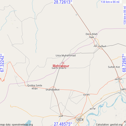
Mehrabpur GPS coordinates[2]
28° 6' 27.828" North, 68° 1' 31.944" East
| Map corner | latitude | longitude |
|---|---|---|
| Upper-left | 28.72613°, | 67.32242° |
| Center: | 28.10773°, | 68.02554° |
| Lower-right: | 27.48575°, | 68.72867° |
| Map W x H: | 137.9×137.9 km | = 85.7×85.7mi |
| max Lat: | 36.32162° ⇑71.8% North |
| Mehrabpur: | 28.10773° |
| min Lat: | ⇓28.2% South 24.14422° |
| min Long | Mehrabpur | max Long |
| 61.74573° | 68.02554° | 75.63372° |
| W 12.6%⇐ | ⇒87.4% E |
Elevation
Elevation of Mehrabpur is 53 m = 174 ft, and this is 292 m = 958 ft below average elevation for this country.
| Max E: |
2732 m = 8963 ft | 80.4% |
| Avg. | 345 m = 1132 ft | |
| Mehrabpur | 53 m = 174 ft | |
Min E: |
3 m = 10 ft | 19.6% |
See also: Pakistan elevation on elevation.city.
Geographical zone
Mehrabpur is located in North temperate zone (between Tropic of Cancer and the Arctic Circle). Distance of this Northern Tropic circle is 519.4 km =322.7 mi to South.| Distance of | km | miles | from Mehrabpur |
|---|---|---|---|
| North Pole | 6881.8 | 4276.2 | to North |
| Arctic Circle | 4275.9 | 2656.9 | to North |
| Tropic Cancer | 519.4 | 322.7 | to South |
| Equator | 3125.3 | 1942 | to South |


Nearby cities:
15 places around Mehrabpur: (largest is in red/bold)
• Chowki Jamali
14.2 km =8.8 mi,  226°
226°
• Dera Allahyar
43.5 km =27 mi,  47°
47°
• Dera Murad Jamali
52.5 km =32.6 mi,  21°
21°
• Garhi Khairo
6.9 km =4.3 mi,  220°
220°
• Garhiyasin
52.8 km =32.8 mi,  115°
115°
• Jacobabad
44.8 km =27.8 mi,  64°
64°
• Kambar
57.9 km =36 mi,  182°
182°
• Larkana
63.7 km =39.6 mi,  163°
163°
• Madeji
57.5 km =35.7 mi,  133°
133°
• Miro Khan
39.2 km =24.4 mi,  170°
170°
• Naudero
59.1 km =36.7 mi,  146°
146°
• Ratodero
42.7 km =26.5 mi,  142°
142°
• Shahdad Kot
31.2 km =19.4 mi,  201°
201°
• Shikarpur
62.5 km =38.8 mi,  105°
105°
• Usta Muhammad
7.9 km =4.9 mi,  12°
12°
Sources, notices
• [Note1] Compared only with cities in Pakistan existing in our database
• [Src1] Map data: © OpenStreetMap contributors (CC-BY-SA)
• [Src2] Other city data from geonames.org with taken over terms of usage.
• [Src3] Geographical zone / Annual Mean Temperature by Robert A. Rohde @ Wikipedia
