Mustafābād geodata
Mustafābād (Punjab) is a populated place; located in Pakistan in Asia/Karachi (GMT+5) time zone. With population of 45,795 people, there are 141 cities with bigger population in this country. Compared to other cities in Pakistan, 53.3% of cities are located further ↓South; 81.7% of cities are located further ←West and 50.3% of cities have higher elevation than Mustafābād. Note1


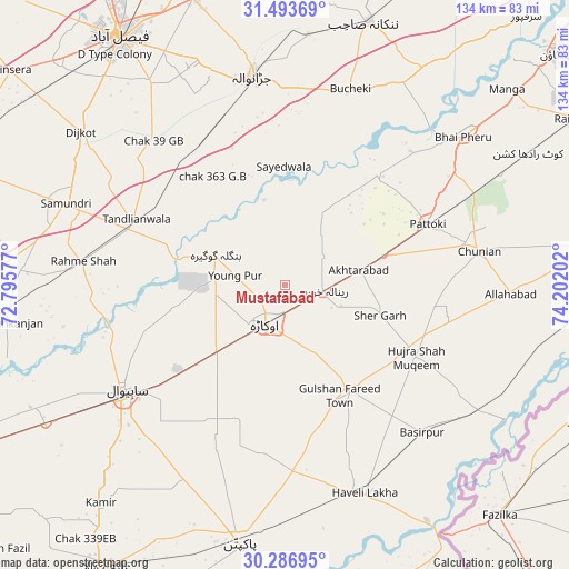
Mustafābād GPS coordinates[2]
30° 53' 31.992" North, 73° 29' 56.004" East
| Map corner | latitude | longitude |
|---|---|---|
| Upper-left | 31.49369°, | 72.79577° |
| Center: | 30.89222°, | 73.49889° |
| Lower-right: | 30.28695°, | 74.20202° |
| Map W x H: | 134.2×134.2 km | = 83.4×83.4mi |
| max Lat: | 36.32162° ⇑46.7% North |
| Mustafābād: | 30.89222° |
| min Lat: | ⇓53.3% South 24.14422° |
| min Long | Mustafābād | max Long |
| 61.74573° | 73.49889° | 75.63372° |
| W 81.7%⇐ | ⇒18.3% E |
Elevation
Elevation of Mustafābād is 178 m = 584 ft, and this is 167 m = 548 ft below average elevation for this country.
| Max E: |
2732 m = 8963 ft | 50.3% |
| Avg. | 345 m = 1132 ft | |
| Mustafābād | 178 m = 584 ft | |
Min E: |
3 m = 10 ft | 49.7% |
See also: Mustafābād elevation on elevation.city.
Geographical zone
Mustafābād is located in North temperate zone (between Tropic of Cancer and the Arctic Circle). Distance of this Northern Tropic circle is 829 km =515.1 mi to South.| Distance of | km | miles | from Mustafābād |
|---|---|---|---|
| North Pole | 6572.2 | 4083.8 | to North |
| Arctic Circle | 3966.3 | 2464.5 | to North |
| Tropic Cancer | 829 | 515.1 | to South |
| Equator | 3434.9 | 2134.3 | to South |


Nearby cities:
15 places around Mustafābād: (largest is in red/bold)
• Bahawalnagar
39.3 km =24.4 mi,  195°
195°
• Basirpur
47.8 km =29.7 mi,  137°
137°
• Chak Azam Sahu
47.6 km =29.6 mi,  250°
250°
• Chunian
46.5 km =28.9 mi,  79°
79°
• Dijkot
60 km =37.3 mi,  307°
307°
• Dipalpur
28.8 km =17.9 mi,  149°
149°
• Haveli Lakha
52.5 km =32.6 mi,  159°
159°
• Hujra Shah Muqim
35.2 km =21.9 mi,  118°
118°
• Jaranwala
49.6 km =30.8 mi,  351°
351°
• Mianke Mor
55 km =34.2 mi,  51°
51°
• Okara
10.2 km =6.3 mi,  206°
206°
• Pattoki
36.7 km =22.8 mi,  67°
67°
• Renala Khurd
9.6 km =6 mi,  98°
98°
• Sahiwal
45.5 km =28.3 mi,  236°
236°
• Tandlianwala
38.3 km =23.8 mi,  294°
294°
Sources, notices
• [Note1] Compared only with cities in Pakistan existing in our database
• [Src1] Map data: © OpenStreetMap contributors (CC-BY-SA)
• [Src2] Other city data from geonames.org with taken over terms of usage.
• [Src3] Geographical zone / Annual Mean Temperature by Robert A. Rohde @ Wikipedia
