Dipalpur geodata
Dipalpur (Punjab) is a populated place; located in Pakistan in Asia/Karachi (GMT+5) time zone. With population of 74,640 people, there are 89 cities with bigger population in this country. Compared to other cities in Pakistan, 51.7% of cities are located further ↑North; 83.5% of cities are located further ←West and 51% of cities have higher elevation than Dipalpur. Note1


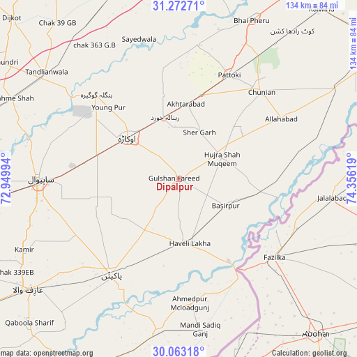
Dipalpur GPS coordinates[2]
30° 40' 11.424" North, 73° 39' 11.016" East
| Map corner | latitude | longitude |
|---|---|---|
| Upper-left | 31.27271°, | 72.94994° |
| Center: | 30.66984°, | 73.65306° |
| Lower-right: | 30.06318°, | 74.35619° |
| Map W x H: | 134.5×134.5 km | = 83.6×83.6mi |
| max Lat: | 36.32162° ⇑51.7% North |
| Dipalpur: | 30.66984° |
| min Lat: | ⇓48.3% South 24.14422° |
| min Long | Dipalpur | max Long |
| 61.74573° | 73.65306° | 75.63372° |
| W 83.5%⇐ | ⇒16.5% E |
Elevation
Elevation of Dipalpur is 176 m = 577 ft, and this is 169 m = 554 ft below average elevation for this country.
| Max E: |
2732 m = 8963 ft | 51% |
| Avg. | 345 m = 1132 ft | |
| Dipalpur | 176 m = 577 ft | |
Min E: |
3 m = 10 ft | 49% |
See also: Dipalpur elevation on elevation.city.
Geographical zone
Dipalpur is located in North temperate zone (between Tropic of Cancer and the Arctic Circle). Distance of this Northern Tropic circle is 804.2 km =499.7 mi to South.| Distance of | km | miles | from Dipalpur |
|---|---|---|---|
| North Pole | 6596.9 | 4099.1 | to North |
| Arctic Circle | 3991 | 2479.9 | to North |
| Tropic Cancer | 804.2 | 499.7 | to South |
| Equator | 3410.2 | 2119 | to South |


Nearby cities:
15 places around Dipalpur: (largest is in red/bold)
• Bahawalnagar
28.4 km =17.6 mi,  242°
242°
• Basirpur
20.5 km =12.7 mi,  119°
119°
• Chak Azam Sahu
60.4 km =37.5 mi,  278°
278°
• Chak One Hundred Twenty Nine Left
64.1 km =39.8 mi,  245°
245°
• Chunian
45.3 km =28.1 mi,  43°
43°
• Haveli Lakha
24.6 km =15.3 mi,  170°
170°
• Hujra Shah Muqim
18.1 km =11.2 mi,  63°
63°
• Kanganpur
46.1 km =28.6 mi,  76°
76°
• Minchianabad
56.9 km =35.4 mi,  188°
188°
• Mustafābād
28.8 km =17.9 mi,  329°
329°
• Okara
24.8 km =15.4 mi,  309°
309°
• Pakpattan
44.2 km =27.5 mi,  214°
214°
• Pattoki
43.4 km =27 mi,  26°
26°
• Renala Khurd
23.8 km =14.8 mi,  347°
347°
• Sahiwal
52.7 km =32.7 mi,  269°
269°
Sources, notices
• [Note1] Compared only with cities in Pakistan existing in our database
• [Src1] Map data: © OpenStreetMap contributors (CC-BY-SA)
• [Src2] Other city data from geonames.org with taken over terms of usage.
• [Src3] Geographical zone / Annual Mean Temperature by Robert A. Rohde @ Wikipedia
