Okara geodata
Okara (Punjab) is a seat of a second-order administrative division; located in Pakistan in Asia/Karachi (GMT+5) time zone. With population of 223,648 people, there are 30 cities with bigger population in this country. Compared to other cities in Pakistan, 52.1% of cities are located further ↓South; 80.6% of cities are located further ←West and 50.6% of cities have lower elevation than Okara. Note1


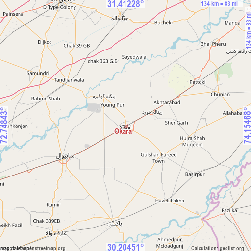
Okara GPS coordinates[2]
30° 48' 37.044" North, 73° 27' 5.58" East
| Map corner | latitude | longitude |
|---|---|---|
| Upper-left | 31.41228°, | 72.74843° |
| Center: | 30.81029°, | 73.45155° |
| Lower-right: | 30.20451°, | 74.15468° |
| Map W x H: | 134.3×134.3 km | = 83.5×83.5mi |
| max Lat: | 36.32162° ⇑47.9% North |
| Okara: | 30.81029° |
| min Lat: | ⇓52.1% South 24.14422° |
| min Long | Okara | max Long |
| 61.74573° | 73.45155° | 75.63372° |
| W 80.6%⇐ | ⇒19.4% E |
Elevation
Elevation of Okara is 181 m = 594 ft, and this is 164 m = 538 ft below average elevation for this country.
| Max E: |
2732 m = 8963 ft | 49.4% |
| Avg. | 345 m = 1132 ft | |
| Okara | 181 m = 594 ft | |
Min E: |
3 m = 10 ft | 50.6% |
See also: Okara elevation on elevation.city.
Geographical zone
Okara is located in North temperate zone (between Tropic of Cancer and the Arctic Circle). Distance of this Northern Tropic circle is 819.9 km =509.5 mi to South.| Distance of | km | miles | from Okara |
|---|---|---|---|
| North Pole | 6581.3 | 4089.4 | to North |
| Arctic Circle | 3975.4 | 2470.2 | to North |
| Tropic Cancer | 819.9 | 509.5 | to South |
| Equator | 3425.8 | 2128.7 | to South |


Nearby cities:
15 places around Okara: (largest is in red/bold)
• Bahawalnagar
29.4 km =18.3 mi,  191°
191°
• Basirpur
45.2 km =28.1 mi,  124°
124°
• Chak Azam Sahu
40.9 km =25.4 mi,  260°
260°
• Chak One Hundred Twenty Nine Left
57.5 km =35.7 mi,  222°
222°
• Chunian
53.2 km =33.1 mi,  70°
70°
• Dipalpur
24.8 km =15.4 mi,  129°
129°
• Haveli Lakha
46.2 km =28.7 mi,  149°
149°
• Hujra Shah Muqim
36.3 km =22.6 mi,  102°
102°
• Jaranwala
58.2 km =36.2 mi,  356°
356°
• Mustafābād
10.2 km =6.3 mi,  26°
26°
• Pakpattan
52.3 km =32.5 mi, 186°
• Pattoki
44.9 km =27.9 mi,  58°
58°
• Renala Khurd
16 km =9.9 mi, 61°
• Sahiwal
37.1 km =23.1 mi,  244°
244°
• Tandlianwala
39.3 km =24.4 mi,  309°
309°
Sources, notices
• [Note1] Compared only with cities in Pakistan existing in our database
• [Src1] Map data: © OpenStreetMap contributors (CC-BY-SA)
• [Src2] Other city data from geonames.org with taken over terms of usage.
• [Src3] Geographical zone / Annual Mean Temperature by Robert A. Rohde @ Wikipedia
