Renala Khurd geodata
Renala Khurd (Punjab) is a populated place; located in Pakistan in Asia/Karachi (GMT+5) time zone. With population of 37,111 people, there are 169 cities with bigger population in this country. Compared to other cities in Pakistan, 53% of cities are located further ↓South; 82.8% of cities are located further ←West and 54.2% of cities have lower elevation than Renala Khurd. Note1


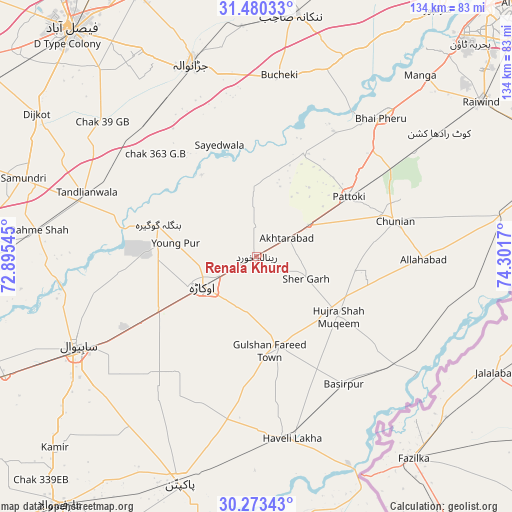
Renala Khurd GPS coordinates[2]
30° 52' 43.608" North, 73° 35' 54.852" East
| Map corner | latitude | longitude |
|---|---|---|
| Upper-left | 31.48033°, | 72.89545° |
| Center: | 30.87878°, | 73.59857° |
| Lower-right: | 30.27343°, | 74.3017° |
| Map W x H: | 134.2×134.2 km | = 83.4×83.4mi |
| max Lat: | 36.32162° ⇑47% North |
| Renala Khurd: | 30.87878° |
| min Lat: | ⇓53% South 24.14422° |
| min Long | Renala Khurd | max Long |
| 61.74573° | 73.59857° | 75.63372° |
| W 82.8%⇐ | ⇒17.2% E |
Elevation
Elevation of Renala Khurd is 189 m = 620 ft, and this is 156 m = 512 ft below average elevation for this country.
| Max E: |
2732 m = 8963 ft | 45.8% |
| Avg. | 345 m = 1132 ft | |
| Renala Khurd | 189 m = 620 ft | |
Min E: |
3 m = 10 ft | 54.2% |
See also: Pakistan elevation on elevation.city.
Geographical zone
Renala Khurd is located in North temperate zone (between Tropic of Cancer and the Arctic Circle). Distance of this Northern Tropic circle is 827.5 km =514.2 mi to South.| Distance of | km | miles | from Renala Khurd |
|---|---|---|---|
| North Pole | 6573.7 | 4084.7 | to North |
| Arctic Circle | 3967.8 | 2465.5 | to North |
| Tropic Cancer | 827.5 | 514.2 | to South |
| Equator | 3433.4 | 2133.4 | to South |


Nearby cities:
15 places around Renala Khurd: (largest is in red/bold)
• Bahawalnagar
41.5 km =25.8 mi,  208°
208°
• Basirpur
40.6 km =25.2 mi,  145°
145°
• Chak Azam Sahu
56.2 km =34.9 mi,  255°
255°
• Chunian
37.6 km =23.4 mi,  75°
75°
• Dipalpur
23.8 km =14.8 mi,  167°
167°
• Haveli Lakha
48.4 km =30.1 mi, 169°
• Hujra Shah Muqim
26.3 km =16.3 mi,  125°
125°
• Jaranwala
53.4 km =33.2 mi,  341°
341°
• Kanganpur
51.6 km =32.1 mi,  104°
104°
• Mianke Mor
49.1 km =30.5 mi,  42°
42°
• Mustafābād
9.6 km =6 mi,  278°
278°
• Okara
16 km =9.9 mi,  241°
241°
• Pattoki
28.9 km =18 mi,  57°
57°
• Sahiwal
53 km =32.9 mi, 243°
• Tandlianwala
47.6 km =29.6 mi,  291°
291°
Sources, notices
• [Note1] Compared only with cities in Pakistan existing in our database
• [Src1] Map data: © OpenStreetMap contributors (CC-BY-SA)
• [Src2] Other city data from geonames.org with taken over terms of usage.
• [Src3] Geographical zone / Annual Mean Temperature by Robert A. Rohde @ Wikipedia
