Baffa geodata
Baffa (Khyber Pakhtunkhwa) is a populated place; located in Pakistan in Asia/Karachi (GMT+5) time zone. With population of 14,047 people, there are 326 cities with bigger population in this country. Compared to other cities in Pakistan, 95% of cities are located further ↓South; 77.4% of cities are located further ←West and 87.8% of cities have lower elevation than Baffa. Note1


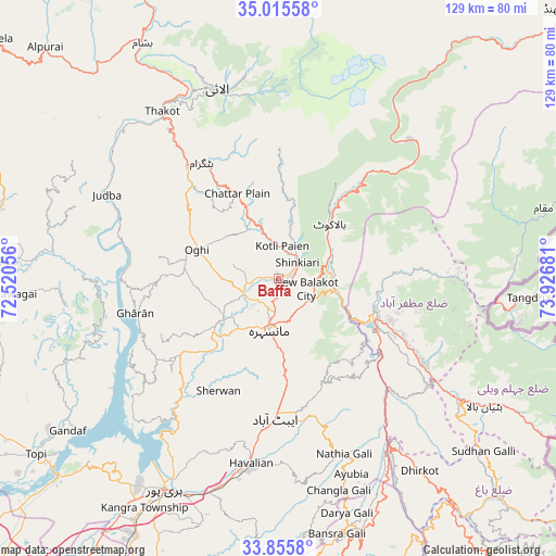
Baffa GPS coordinates[2]
34° 26' 15.72" North, 73° 13' 25.248" East
| Map corner | latitude | longitude |
|---|---|---|
| Upper-left | 35.01558°, | 72.52056° |
| Center: | 34.4377°, | 73.22368° |
| Lower-right: | 33.8558°, | 73.92681° |
| Map W x H: | 129×129 km | = 80.2×80.2mi |
| max Lat: | 36.32162° ⇑5% North |
| Baffa: | 34.4377° |
| min Lat: | ⇓95% South 24.14422° |
| min Long | Baffa | max Long |
| 61.74573° | 73.22368° | 75.63372° |
| W 77.4%⇐ | ⇒22.6% E |
Elevation
Elevation of Baffa is 923 m = 3028 ft, and this is 578 m = 1896 ft above average elevation for this country.
| Max E: |
2732 m = 8963 ft | 12.2% |
| Baffa | 923 m 3028 ft | |
| Avg. | 345 m = 1132 ft | |
Min E: |
3 m = 10 ft | 87.8% |
See also: Pakistan elevation on elevation.city.
Geographical zone
Baffa is located in North temperate zone (between Tropic of Cancer and the Arctic Circle). Distance of this Northern Tropic circle is 1223.2 km =760.1 mi to South.| Distance of | km | miles | from Baffa |
|---|---|---|---|
| North Pole | 6177.9 | 3838.8 | to North |
| Arctic Circle | 3572.1 | 2219.6 | to North |
| Tropic Cancer | 1223.2 | 760.1 | to South |
| Equator | 3829.1 | 2379.3 | to South |


Nearby cities:
15 places around Baffa: (largest is in red/bold)
• Abbottabad
32.4 km =20.1 mi,  181°
181°
• Amirabad
30.4 km =18.9 mi,  203°
203°
• Athmuqam
63.5 km =39.5 mi,  76°
76°
• Bagh
71.8 km =44.6 mi,  134°
134°
• Battagram
32.3 km =20.1 mi,  325°
325°
• Daggar
68.3 km =42.4 mi,  276°
276°
• Haripur
55.6 km =34.5 mi,  208°
208°
• Hattian Bala
56.3 km =35 mi,  122°
122°
• Havelian
43.1 km =26.8 mi,  187°
187°
• Khalabat
52 km =32.3 mi,  216°
216°
• Mansehra
12.2 km =7.6 mi, 191°
• Murree
60.8 km =37.8 mi,  165°
165°
• Muzaffarābād
23.9 km =14.9 mi,  108°
108°
• Shingli Bala
34.6 km =21.5 mi,  320°
320°
• Topi
68.8 km =42.8 mi,  233°
233°
Sources, notices
• [Note1] Compared only with cities in Pakistan existing in our database
• [Src1] Map data: © OpenStreetMap contributors (CC-BY-SA)
• [Src2] Other city data from geonames.org with taken over terms of usage.
• [Src3] Geographical zone / Annual Mean Temperature by Robert A. Rohde @ Wikipedia
