Mansehra geodata
Mansehra (Khyber Pakhtunkhwa) is a seat of a second-order administrative division; located in Pakistan in Asia/Karachi (GMT+5) time zone. With population of 66,486 people, there are 106 cities with bigger population in this country. Compared to other cities in Pakistan, 94.6% of cities are located further ↓South; 76.5% of cities are located further ←West and 90.5% of cities have lower elevation than Mansehra. Note1


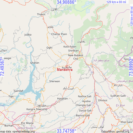
Mansehra GPS coordinates[2]
34° 19' 48.828" North, 73° 11' 48.444" East
| Map corner | latitude | longitude |
|---|---|---|
| Upper-left | 34.90886°, | 72.49367° |
| Center: | 34.33023°, | 73.19679° |
| Lower-right: | 33.74758°, | 73.89992° |
| Map W x H: | 129.1×129.1 km | = 80.2×80.2mi |
| max Lat: | 36.32162° ⇑5.4% North |
| Mansehra: | 34.33023° |
| min Lat: | ⇓94.6% South 24.14422° |
| min Long | Mansehra | max Long |
| 61.74573° | 73.19679° | 75.63372° |
| W 76.5%⇐ | ⇒23.5% E |
Elevation
Elevation of Mansehra is 1079 m = 3540 ft, and this is 734 m = 2408 ft above average elevation for this country.
| Max E: |
2732 m = 8963 ft | 9.5% |
| Mansehra | 1079 m 3540 ft | |
| Avg. | 345 m = 1132 ft | |
Min E: |
3 m = 10 ft | 90.5% |
See also: Mansehra elevation on elevation.city.
Geographical zone
Mansehra is located in North temperate zone (between Tropic of Cancer and the Arctic Circle). Distance of this Northern Tropic circle is 1211.2 km =752.6 mi to South.| Distance of | km | miles | from Mansehra |
|---|---|---|---|
| North Pole | 6189.9 | 3846.2 | to North |
| Arctic Circle | 3584 | 2227 | to North |
| Tropic Cancer | 1211.2 | 752.6 | to South |
| Equator | 3817.2 | 2371.9 | to South |


Nearby cities:
15 places around Mansehra: (largest is in red/bold)
• Abbottabad
20.5 km =12.7 mi,  176°
176°
• Amirabad
18.6 km =11.6 mi,  211°
211°
• Baffa
12.2 km =7.6 mi,  11°
11°
• Bagh
65.9 km =40.9 mi,  126°
126°
• Battagram
41.7 km =25.9 mi,  337°
337°
• Daggar
68.4 km =42.5 mi,  287°
287°
• Haripur
44.1 km =27.4 mi, 213°
• Hattian Bala
53.3 km =33.1 mi,  109°
109°
• Havelian
31 km =19.3 mi,  186°
186°
• Islamabad
69.1 km =42.9 mi, 191°
• Khalabat
41.2 km =25.6 mi,  223°
223°
• Murree
50.2 km =31.2 mi,  159°
159°
• Muzaffarābād
25.5 km =15.8 mi,  80°
80°
• Shingli Bala
43.3 km =26.9 mi,  333°
333°
• Topi
60.3 km =37.5 mi,  241°
241°
Sources, notices
• [Note1] Compared only with cities in Pakistan existing in our database
• [Src1] Map data: © OpenStreetMap contributors (CC-BY-SA)
• [Src2] Other city data from geonames.org with taken over terms of usage.
• [Src3] Geographical zone / Annual Mean Temperature by Robert A. Rohde @ Wikipedia
