Bhimbar geodata
Bhimbar (Azad Kashmir) is a populated place; located in Pakistan in Asia/Karachi (GMT+5) time zone. With population of 342,900 people, there are 20 cities with bigger population in this country. Compared to other cities in Pakistan, 82.6% of cities are located further ↓South; 90.5% of cities are located further ←West and 77.4% of cities have lower elevation than Bhimbar. Note1


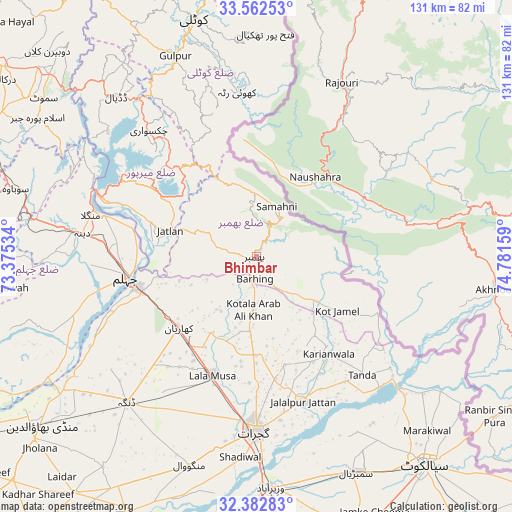
Bhimbar GPS coordinates[2]
32° 58' 28.74" North, 74° 4' 42.456" East
| Map corner | latitude | longitude |
|---|---|---|
| Upper-left | 33.56253°, | 73.37534° |
| Center: | 32.97465°, | 74.07846° |
| Lower-right: | 32.38283°, | 74.78159° |
| Map W x H: | 131.2×131.2 km | = 81.5×81.5mi |
| max Lat: | 36.32162° ⇑17.4% North |
| Bhimbar: | 32.97465° |
| min Lat: | ⇓82.6% South 24.14422° |
| min Long | Bhimbar | max Long |
| 61.74573° | 74.07846° | 75.63372° |
| W 90.5%⇐ | ⇒9.5% E |
Elevation
Elevation of Bhimbar is 332 m = 1089 ft, and this is 13 m = 43 ft below average elevation for this country.
| Max E: |
2732 m = 8963 ft | 22.6% |
| Avg. | 345 m = 1132 ft | |
| Bhimbar | 332 m = 1089 ft | |
Min E: |
3 m = 10 ft | 77.4% |
See also: Bhimbar elevation on elevation.city.
Geographical zone
Bhimbar is located in North temperate zone (between Tropic of Cancer and the Arctic Circle). Distance of this Northern Tropic circle is 1060.5 km =659 mi to South.| Distance of | km | miles | from Bhimbar |
|---|---|---|---|
| North Pole | 6340.6 | 3939.9 | to North |
| Arctic Circle | 3734.7 | 2320.6 | to North |
| Tropic Cancer | 1060.5 | 659 | to South |
| Equator | 3666.4 | 2278.2 | to South |


Nearby cities:
15 places around Bhimbar: (largest is in red/bold)
• Dinga
50 km =31.1 mi,  222°
222°
• Gujrat
44.5 km =27.7 mi,  180°
180°
• Hadali
59 km =36.7 mi,  129°
129°
• Jalalpur Jattan
38.9 km =24.2 mi,  162°
162°
• Jhelum
32.7 km =20.3 mi,  262°
262°
• Kharian
25.1 km =15.6 mi,  225°
225°
• Kotli Loharan
57.9 km =36 mi,  137°
137°
• Kunjah
50.4 km =31.3 mi,  191°
191°
• Lala Musa
32.4 km =20.1 mi,  200°
200°
• Mehmand Chak
31.8 km =19.8 mi, 228°
• New Mirpur
36 km =22.4 mi,  302°
302°
• Sarai Alamgir
31.1 km =19.3 mi, 255°
• Sodhri
57.8 km =35.9 mi,  170°
170°
• Surkhpur
44.8 km =27.8 mi, 129°
• Wazirabad
59.2 km =36.8 mi, 176°
Sources, notices
• [Note1] Compared only with cities in Pakistan existing in our database
• [Src1] Map data: © OpenStreetMap contributors (CC-BY-SA)
• [Src2] Other city data from geonames.org with taken over terms of usage.
• [Src3] Geographical zone / Annual Mean Temperature by Robert A. Rohde @ Wikipedia
