Gandava geodata
Gandava (Balochistan) is a seat of a second-order administrative division; located in Pakistan in Asia/Karachi (GMT+5) time zone. In our database, there are 416 cities with bigger population. Compared to other cities in Pakistan, 67.9% of cities are located further ↑North; 94.1% of cities are located further →East and 69.8% of cities have higher elevation than Gandava. Note1


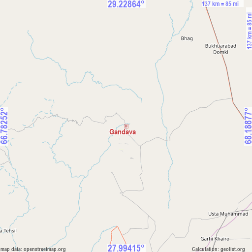
Gandava GPS coordinates[2]
28° 36' 47.556" North, 67° 29' 8.304" East
| Map corner | latitude | longitude |
|---|---|---|
| Upper-left | 29.22864°, | 66.78252° |
| Center: | 28.61321°, | 67.48564° |
| Lower-right: | 27.99415°, | 68.18877° |
| Map W x H: | 137.3×137.3 km | = 85.3×85.3mi |
| max Lat: | 36.32162° ⇑67.9% North |
| Gandava: | 28.61321° |
| min Lat: | ⇓32.1% South 24.14422° |
| min Long | Gandava | max Long |
| 61.74573° | 67.48564° | 75.63372° |
| W 5.9%⇐ | ⇒94.1% E |
Elevation
Elevation of Gandava is 88 m = 289 ft, and this is 257 m = 843 ft below average elevation for this country.
| Max E: |
2732 m = 8963 ft | 69.8% |
| Avg. | 345 m = 1132 ft | |
| Gandava | 88 m = 289 ft | |
Min E: |
3 m = 10 ft | 30.2% |
See also: Pakistan elevation on elevation.city.
Geographical zone
Gandava is located in North temperate zone (between Tropic of Cancer and the Arctic Circle). Distance of this Northern Tropic circle is 575.6 km =357.7 mi to South.| Distance of | km | miles | from Gandava |
|---|---|---|---|
| North Pole | 6825.6 | 4241.2 | to North |
| Arctic Circle | 4219.7 | 2622 | to North |
| Tropic Cancer | 575.6 | 357.7 | to South |
| Equator | 3181.5 | 1976.9 | to South |


Nearby cities:
15 places around Gandava: (largest is in red/bold)
• Bhag
57.9 km =36 mi,  34°
34°
• Chowki Jamali
78.6 km =48.8 mi,  147°
147°
• Dadhar
97.2 km =60.4 mi,  9°
9°
• Dera Allahyar
88.6 km =55.1 mi,  107°
107°
• Dera Murad Jamali
72.4 km =45 mi,  95°
95°
• Garhi Khairo
78.3 km =48.7 mi,  141°
141°
• Jacobabad
100.1 km =62.2 mi, 111°
• Kalat
98.3 km =61.1 mi,  297°
297°
• Mehrabpur
77.1 km =47.9 mi, 136°
• Miro Khan
112 km =69.6 mi, 147°
• Ratodero
119.7 km =74.4 mi, 138°
• Shahdad Kot
94.6 km =58.8 mi, 154°
• Sibi
110.2 km =68.5 mi,  20°
20°
• Sohbatpur
103.8 km =64.5 mi, 95°
• Usta Muhammad
73 km =45.4 mi,  131°
131°
Sources, notices
• [Note1] Compared only with cities in Pakistan existing in our database
• [Src1] Map data: © OpenStreetMap contributors (CC-BY-SA)
• [Src2] Other city data from geonames.org with taken over terms of usage.
• [Src3] Geographical zone / Annual Mean Temperature by Robert A. Rohde @ Wikipedia
