Bannu geodata
Bannu (Khyber Pakhtunkhwa) is a seat of a second-order administrative division; located in Pakistan in Asia/Karachi (GMT+5) time zone. With population of 49,008 people, there are 132 cities with bigger population in this country. Compared to other cities in Pakistan, 82.8% of cities are located further ↓South; 59.4% of cities are located further →East and 79.9% of cities have lower elevation than Bannu. Note1


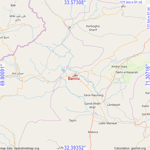
Bannu GPS coordinates[2]
32° 59' 6.972" North, 70° 36' 14.508" East
| Map corner | latitude | longitude |
|---|---|---|
| Upper-left | 33.57308°, | 69.90091° |
| Center: | 32.98527°, | 70.60403° |
| Lower-right: | 32.39352°, | 71.30716° |
| Map W x H: | 131.2×131.2 km | = 81.5×81.5mi |
| max Lat: | 36.32162° ⇑17.2% North |
| Bannu: | 32.98527° |
| min Lat: | ⇓82.8% South 24.14422° |
| min Long | Bannu | max Long |
| 61.74573° | 70.60403° | 75.63372° |
| W 40.6%⇐ | ⇒59.4% E |
Elevation
Elevation of Bannu is 379 m = 1243 ft, and this is 34 m = 112 ft above average elevation for this country.
| Max E: |
2732 m = 8963 ft | 20.1% |
| Bannu | 379 m 1243 ft | |
| Avg. | 345 m = 1132 ft | |
Min E: |
3 m = 10 ft | 79.9% |
See also: Bannu elevation on elevation.city.
Geographical zone
Bannu is located in North temperate zone (between Tropic of Cancer and the Arctic Circle). Distance of this Northern Tropic circle is 1061.7 km =659.7 mi to South.| Distance of | km | miles | from Bannu |
|---|---|---|---|
| North Pole | 6339.4 | 3939.1 | to North |
| Arctic Circle | 3733.6 | 2320 | to North |
| Tropic Cancer | 1061.7 | 659.7 | to South |
| Equator | 3667.6 | 2278.9 | to South |


Nearby cities:
15 places around Bannu: (largest is in red/bold)
• Alizai
65.8 km =40.9 mi,  338°
338°
• Daud Khel
91.1 km =56.6 mi,  97°
97°
• Doaba
50.4 km =31.3 mi,  14°
14°
• Gulishah Kach
42.8 km =26.6 mi,  215°
215°
• Hangu
74.1 km =46 mi,  34°
34°
• Kalabagh
87.9 km =54.6 mi,  91°
91°
• Kamar Mushani
72.5 km =45 mi, 102°
• Karak
47.9 km =29.8 mi,  72°
72°
• Kundian
100.7 km =62.6 mi,  125°
125°
• Lachi
81.3 km =50.5 mi,  57°
57°
• Lakki
51 km =31.7 mi,  145°
145°
• Mianwali
97.6 km =60.6 mi,  117°
117°
• Miran Shah
49.7 km =30.9 mi,  271°
271°
• Sarai Naurang
24.2 km =15 mi,  137°
137°
• Tank
87.9 km =54.6 mi,  193°
193°
Sources, notices
• [Note1] Compared only with cities in Pakistan existing in our database
• [Src1] Map data: © OpenStreetMap contributors (CC-BY-SA)
• [Src2] Other city data from geonames.org with taken over terms of usage.
• [Src3] Geographical zone / Annual Mean Temperature by Robert A. Rohde @ Wikipedia
