Kamar Mushani geodata
Kamar Mushani (Punjab) is a populated place; located in Pakistan in Asia/Karachi (GMT+5) time zone. With population of 15,867 people, there are 306 cities with bigger population in this country. Compared to other cities in Pakistan, 80.8% of cities are located further ↓South; 51% of cities are located further →East and 63% of cities have lower elevation than Kamar Mushani. Note1


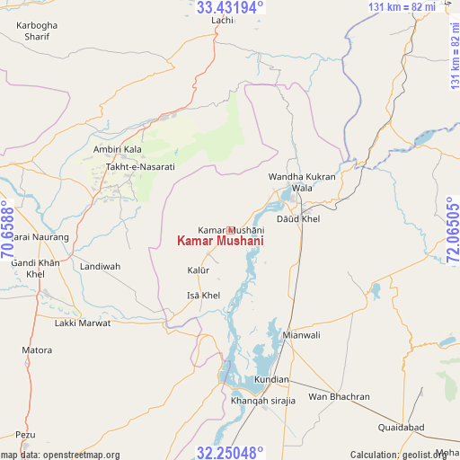
Kamar Mushani GPS coordinates[2]
32° 50' 35.448" North, 71° 21' 42.912" East
| Map corner | latitude | longitude |
|---|---|---|
| Upper-left | 33.43194°, | 70.6588° |
| Center: | 32.84318°, | 71.36192° |
| Lower-right: | 32.25048°, | 72.06505° |
| Map W x H: | 131.4×131.4 km | = 81.6×81.6mi |
| max Lat: | 36.32162° ⇑19.2% North |
| Kamar Mushani: | 32.84318° |
| min Lat: | ⇓80.8% South 24.14422° |
| min Long | Kamar Mushani | max Long |
| 61.74573° | 71.36192° | 75.63372° |
| W 49%⇐ | ⇒51% E |
Elevation
Elevation of Kamar Mushani is 213 m = 699 ft, and this is 132 m = 433 ft below average elevation for this country.
| Max E: |
2732 m = 8963 ft | 37% |
| Avg. | 345 m = 1132 ft | |
| Kamar Mushani | 213 m = 699 ft | |
Min E: |
3 m = 10 ft | 63% |
See also: Pakistan elevation on elevation.city.
Geographical zone
Kamar Mushani is located in North temperate zone (between Tropic of Cancer and the Arctic Circle). Distance of this Northern Tropic circle is 1045.9 km =649.9 mi to South.| Distance of | km | miles | from Kamar Mushani |
|---|---|---|---|
| North Pole | 6355.2 | 3948.9 | to North |
| Arctic Circle | 3749.4 | 2329.8 | to North |
| Tropic Cancer | 1045.9 | 649.9 | to South |
| Equator | 3651.8 | 2269.1 | to South |


Nearby cities:
15 places around Kamar Mushani: (largest is in red/bold)
• Bannu
72.5 km =45 mi,  282°
282°
• Daud Khel
19.9 km =12.4 mi,  79°
79°
• Doaba
87 km =54.1 mi,  317°
317°
• Hangu
81.6 km =50.7 mi,  339°
339°
• Harnoli
65.3 km =40.6 mi,  163°
163°
• Jand
89.7 km =55.7 mi,  42°
42°
• Kalabagh
21.7 km =13.5 mi,  52°
52°
• Kalur Kot
77 km =47.8 mi,  186°
186°
• Karak
39.4 km =24.5 mi, 320°
• Kohat
82.5 km =51.3 mi,  5°
5°
• Kundian
44.2 km =27.5 mi,  165°
165°
• Lachi
60.1 km =37.3 mi,  357°
357°
• Lakki
49.6 km =30.8 mi,  238°
238°
• Mianwali
33.4 km =20.8 mi,  152°
152°
• Sarai Naurang
54.3 km =33.7 mi,  267°
267°
Sources, notices
• [Note1] Compared only with cities in Pakistan existing in our database
• [Src1] Map data: © OpenStreetMap contributors (CC-BY-SA)
• [Src2] Other city data from geonames.org with taken over terms of usage.
• [Src3] Geographical zone / Annual Mean Temperature by Robert A. Rohde @ Wikipedia
