Chitral geodata
Chitral (Khyber Pakhtunkhwa) is a seat of a second-order administrative division; located in Pakistan in Asia/Karachi (GMT+5) time zone. In our database, there are 416 cities with bigger population. Compared to other cities in Pakistan, 99.1% of cities are located further ↓South; 54% of cities are located further ←West and 95.3% of cities have lower elevation than Chitral. Note1


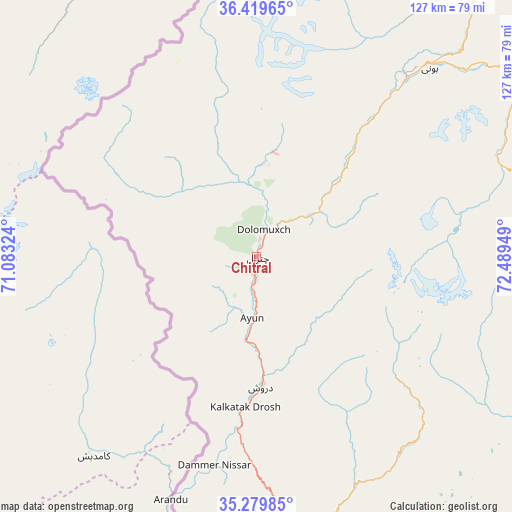
Chitral GPS coordinates[2]
35° 51' 6.48" North, 71° 47' 10.896" East
| Map corner | latitude | longitude |
|---|---|---|
| Upper-left | 36.41965°, | 71.08324° |
| Center: | 35.8518°, | 71.78636° |
| Lower-right: | 35.27985°, | 72.48949° |
| Map W x H: | 126.7×126.7 km | = 78.7×78.7mi |
| max Lat: | 36.32162° ⇑0.9% North |
| Chitral: | 35.8518° |
| min Lat: | ⇓99.1% South 24.14422° |
| min Long | Chitral | max Long |
| 61.74573° | 71.78636° | 75.63372° |
| W 54%⇐ | ⇒46% E |
Elevation
Elevation of Chitral is 1473 m = 4833 ft, and this is 1128 m = 3701 ft above average elevation for this country.
| Max E: |
2732 m = 8963 ft | 4.7% |
| Chitral | 1473 m 4833 ft | |
| Avg. | 345 m = 1132 ft | |
Min E: |
3 m = 10 ft | 95.3% |
See also: Pakistan elevation on elevation.city.
Geographical zone
Chitral is located in North temperate zone (between Tropic of Cancer and the Arctic Circle). Distance of this Northern Tropic circle is 1380.4 km =857.7 mi to South.| Distance of | km | miles | from Chitral |
|---|---|---|---|
| North Pole | 6020.7 | 3741.1 | to North |
| Arctic Circle | 3414.8 | 2121.9 | to North |
| Tropic Cancer | 1380.4 | 857.7 | to South |
| Equator | 3986.3 | 2477 | to South |


Nearby cities:
15 places around Chitral: (largest is in red/bold)
• Alpurai
128.9 km =80.1 mi,  143°
143°
• Bat Khela
138.2 km =85.9 mi,  172°
172°
• Battagram
172.2 km =107 mi, 139°
• Daggar
162 km =100.7 mi,  156°
156°
• Dasu
149.6 km =93 mi,  114°
114°
• Kakad Wari Dir Upper
98.4 km =61.1 mi, 164°
• Malakand
143.6 km =89.2 mi, 174°
• Mingora
130.2 km =80.9 mi, 156°
• Saidu Sharif
133.3 km =82.8 mi, 157°
• Shingli Bala
169.9 km =105.6 mi, 140°
• Shinpokh
178.1 km =110.7 mi,  198°
198°
• Tangi
172.9 km =107.4 mi,  184°
184°
• Thal
58.6 km =36.4 mi, 135°
• Timargara
114.1 km =70.9 mi, 177°
• Upper Dir
72.1 km =44.8 mi, 173°
Sources, notices
• [Note1] Compared only with cities in Pakistan existing in our database
• [Src1] Map data: © OpenStreetMap contributors (CC-BY-SA)
• [Src2] Other city data from geonames.org with taken over terms of usage.
• [Src3] Geographical zone / Annual Mean Temperature by Robert A. Rohde @ Wikipedia
