Wartkowice geodata
Wartkowice (Łódź Voivodeship) is a seat of a third-order administrative division; located in Poland in Europe/Warsaw (GMT+2) time zone. With population of 691 people, there are 3087 cities with bigger population in this country. Compared to other cities in Poland, 65.3% of cities are located further ↓South; 60% of cities are located further →East and 75% of cities have higher elevation than Wartkowice. Note1
Administrative division(s):
- Level 1: Łódź Voivodeship
- Level 2: Powiat poddębicki
- Level 3: Wartkowice


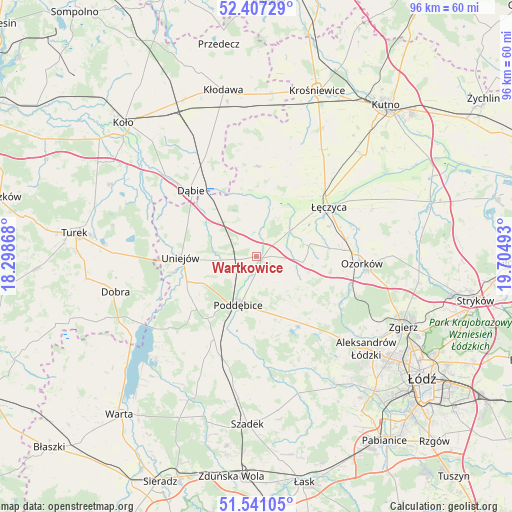
Wartkowice GPS coordinates[2]
51° 58' 34.536" North, 19° 0' 6.48" East
| Map corner | latitude | longitude |
|---|---|---|
| Upper-left | 52.40729°, | 18.29868° |
| Center: | 51.97626°, | 19.0018° |
| Lower-right: | 51.54105°, | 19.70493° |
| Map W x H: | 96.3×96.3 km | = 59.8×59.8mi |
| max Lat: | 54.83135° ⇑34.7% North |
| Wartkowice: | 51.97626° |
| min Lat: | ⇓65.3% South 49.21328° |
| min Long | Wartkowice | max Long |
| 14.20249° | 19.0018° | 24.03723° |
| W 40%⇐ | ⇒60% E |
Elevation
Elevation of Wartkowice is 111 m = 364 ft, and this is 80.4 m = 264 ft below average elevation for this country.
| Max E: |
974 m = 3196 ft | 75% |
| Avg. | 191.4 m = 628 ft | |
| Wartkowice | 111 m = 364 ft | |
Min E: |
-3 m = -10 ft | 25% |
See also: Poland elevation on elevation.city.
Geographical zone
Wartkowice is located in North temperate zone (between Tropic of Cancer and the Arctic Circle). Distance of this North polar circle is 1622 km =1007.9 mi to North.| Distance of | km | miles | from Wartkowice |
|---|---|---|---|
| North Pole | 4227.8 | 2627 | to North |
| Arctic Circle | 1622 | 1007.9 | to North |
| Tropic Cancer | 3173.3 | 1971.8 | to South |
| Equator | 5779.2 | 3591 | to South |


Nearby cities:
15 places around Wartkowice: (largest is in red/bold)
• Błonie
14.5 km =9 mi,  39°
39°
• Dalików
13 km =8.1 mi,  141°
141°
• Daszyna
23.4 km =14.5 mi,  31°
31°
• Dąbie
17.4 km =10.8 mi,  315°
315°
• Grabów
16.8 km =10.4 mi,  0°
0°
• Góra Świętej Małgorzaty
23.6 km =14.7 mi,  67°
67°
• Olszówka
25.6 km =15.9 mi,  338°
338°
• Ozorków
19.9 km =12.4 mi,  94°
94°
• Parzęczew
14.3 km =8.9 mi,  102°
102°
• Poddębice
9.7 km =6 mi,  198°
198°
• Przykona
26.7 km =16.6 mi,  271°
271°
• Uniejów
14.3 km =8.9 mi, 269°
• Zadzim
24.5 km =15.2 mi,  205°
205°
• Łęczyca
16.4 km =10.2 mi,  55°
55°
• Świnice Warckie
9.2 km =5.7 mi, 321°
Sources, notices
• [Note1] Compared only with cities in Poland existing in our database
• [Src1] Map data: © OpenStreetMap contributors (CC-BY-SA)
• [Src2] Other city data from geonames.org with taken over terms of usage.
• [Src3] Geographical zone / Annual Mean Temperature by Robert A. Rohde @ Wikipedia
