Wronki geodata
Wronki (Greater Poland) is a seat of a third-order administrative division; located in Poland in Europe/Warsaw (GMT+2) time zone. With population of 11,462 people, there are 407 cities with bigger population in this country. Compared to other cities in Poland, 79.4% of cities are located further ↓South; 90.2% of cities are located further →East and 94.5% of cities have higher elevation than Wronki. Note1


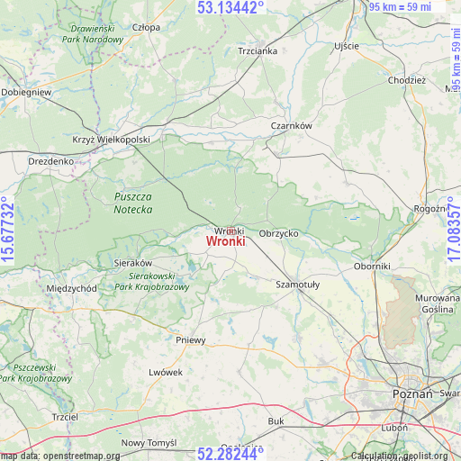
Wronki GPS coordinates[2]
52° 42' 37.836" North, 16° 22' 49.584" East
| Map corner | latitude | longitude |
|---|---|---|
| Upper-left | 53.13442°, | 15.67732° |
| Center: | 52.71051°, | 16.38044° |
| Lower-right: | 52.28244°, | 17.08357° |
| Map W x H: | 94.7×94.7 km | = 58.8×58.8mi |
| max Lat: | 54.83135° ⇑20.6% North |
| Wronki: | 52.71051° |
| min Lat: | ⇓79.4% South 49.21328° |
| min Long | Wronki | max Long |
| 14.20249° | 16.38044° | 24.03723° |
| W 9.8%⇐ | ⇒90.2% E |
Elevation
Elevation of Wronki is 47 m = 154 ft, and this is 144.4 m = 474 ft below average elevation for this country.
| Max E: |
974 m = 3196 ft | 94.5% |
| Avg. | 191.4 m = 628 ft | |
| Wronki | 47 m = 154 ft | |
Min E: |
-3 m = -10 ft | 5.5% |
See also: Poland elevation on elevation.city.
Geographical zone
Wronki is located in North temperate zone (between Tropic of Cancer and the Arctic Circle). Distance of this North polar circle is 1540.3 km =957.1 mi to North.| Distance of | km | miles | from Wronki |
|---|---|---|---|
| North Pole | 4146.2 | 2576.3 | to North |
| Arctic Circle | 1540.3 | 957.1 | to North |
| Tropic Cancer | 3254.9 | 2022.5 | to South |
| Equator | 5860.9 | 3641.8 | to South |


Nearby cities:
15 places around Wronki: (largest is in red/bold)
• Chrzypsko Wielkie
13.7 km =8.5 mi,  228°
228°
• Czarnków
24.6 km =15.3 mi,  30°
30°
• Kaźmierz
25.9 km =16.1 mi,  147°
147°
• Kwilcz
26.4 km =16.4 mi, 229°
• Lipnica
16.9 km =10.5 mi,  156°
156°
• Lubasz
18.5 km =11.5 mi, 31°
• Lutom
18.6 km =11.6 mi,  239°
239°
• Obrzycko
10 km =6.2 mi,  94°
94°
• Ostroróg
10.4 km =6.5 mi, 153°
• Pamiątkowo
26.8 km =16.7 mi,  130°
130°
• Pniewy
23.9 km =14.9 mi,  200°
200°
• Połajewo
25.7 km =16 mi,  67°
67°
• Sieraków
21.3 km =13.2 mi,  251°
251°
• Szamotuły
17.2 km =10.7 mi, 129°
• Wieleń
24.8 km =15.4 mi,  325°
325°
Sources, notices
• [Note1] Compared only with cities in Poland existing in our database
• [Src1] Map data: © OpenStreetMap contributors (CC-BY-SA)
• [Src2] Other city data from geonames.org with taken over terms of usage.
• [Src3] Geographical zone / Annual Mean Temperature by Robert A. Rohde @ Wikipedia
