Lipnica geodata
Lipnica (Greater Poland) is a populated place; located in Poland in Europe/Warsaw (GMT+2) time zone. With population of 1,000 people, there are 2459 cities with bigger population in this country. Compared to other cities in Poland, 77.5% of cities are located further ↓South; 89.7% of cities are located further →East and 82.2% of cities have higher elevation than Lipnica. Note1


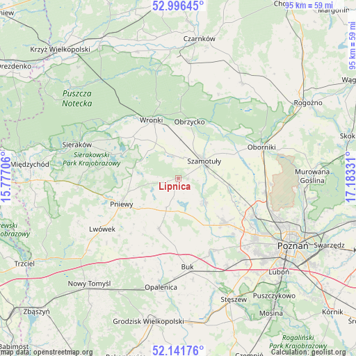
Lipnica GPS coordinates[2]
52° 34' 16.284" North, 16° 28' 48.648" East
| Map corner | latitude | longitude |
|---|---|---|
| Upper-left | 52.99645°, | 15.77706° |
| Center: | 52.57119°, | 16.48018° |
| Lower-right: | 52.14176°, | 17.18331° |
| Map W x H: | 95×95 km | = 59×59mi |
| max Lat: | 54.83135° ⇑22.5% North |
| Lipnica: | 52.57119° |
| min Lat: | ⇓77.5% South 49.21328° |
| min Long | Lipnica | max Long |
| 14.20249° | 16.48018° | 24.03723° |
| W 10.3%⇐ | ⇒89.7% E |
Elevation
Elevation of Lipnica is 95 m = 312 ft, and this is 96.4 m = 316 ft below average elevation for this country.
| Max E: |
974 m = 3196 ft | 82.2% |
| Avg. | 191.4 m = 628 ft | |
| Lipnica | 95 m = 312 ft | |
Min E: |
-3 m = -10 ft | 17.8% |
See also: Poland elevation on elevation.city.
Geographical zone
Lipnica is located in North temperate zone (between Tropic of Cancer and the Arctic Circle). Distance of this North polar circle is 1555.8 km =966.7 mi to North.| Distance of | km | miles | from Lipnica |
|---|---|---|---|
| North Pole | 4161.7 | 2586 | to North |
| Arctic Circle | 1555.8 | 966.7 | to North |
| Tropic Cancer | 3239.4 | 2012.9 | to South |
| Equator | 5845.4 | 3632.2 | to South |


Nearby cities:
15 places around Lipnica: (largest is in red/bold)
• Brody
19.3 km =12 mi,  220°
220°
• Chrzypsko Wielkie
18.1 km =11.2 mi,  290°
290°
• Duszniki
14.7 km =9.1 mi,  199°
199°
• Kaźmierz
9.5 km =5.9 mi,  132°
132°
• Lutom
23.6 km =14.7 mi,  284°
284°
• Objezierze
19.4 km =12.1 mi,  78°
78°
• Obrzycko
15 km =9.3 mi,  12°
12°
• Ostroróg
6.5 km =4 mi,  341°
341°
• Pakosław
21.9 km =13.6 mi,  226°
226°
• Pamiątkowo
13.7 km =8.5 mi,  98°
98°
• Pniewy
16.6 km =10.3 mi,  245°
245°
• Rokietnica
19.1 km =11.9 mi,  109°
109°
• Szamotuły
8 km =5 mi,  55°
55°
• Tarnowo Podgórne
17 km =10.6 mi, 133°
• Wronki
16.9 km =10.5 mi, 336°
Sources, notices
• [Note1] Compared only with cities in Poland existing in our database
• [Src1] Map data: © OpenStreetMap contributors (CC-BY-SA)
• [Src2] Other city data from geonames.org with taken over terms of usage.
• [Src3] Geographical zone / Annual Mean Temperature by Robert A. Rohde @ Wikipedia
