Nagłowice geodata
Nagłowice (Świętokrzyskie) is a seat of a third-order administrative division; located in Poland in Europe/Warsaw (GMT+2) time zone. With population of 950 people, there are 2592 cities with bigger population in this country. Compared to other cities in Poland, 63.1% of cities are located further ↑North; 60.1% of cities are located further ←West and 74.6% of cities have lower elevation than Nagłowice. Note1


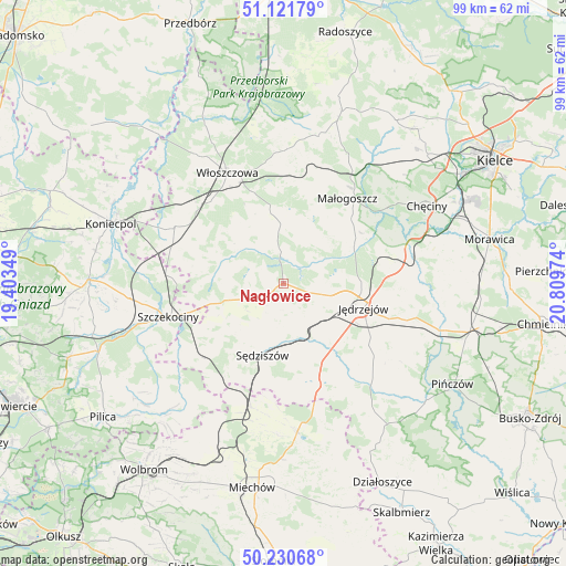
Nagłowice GPS coordinates[2]
50° 40' 42.06" North, 20° 6' 23.796" East
| Map corner | latitude | longitude |
|---|---|---|
| Upper-left | 51.12179°, | 19.40349° |
| Center: | 50.67835°, | 20.10661° |
| Lower-right: | 50.23068°, | 20.80974° |
| Map W x H: | 99.1×99.1 km | = 61.6×61.6mi |
| max Lat: | 54.83135° ⇑63.1% North |
| Nagłowice: | 50.67835° |
| min Lat: | ⇓36.9% South 49.21328° |
| min Long | Nagłowice | max Long |
| 14.20249° | 20.10661° | 24.03723° |
| W 60.1%⇐ | ⇒39.9% E |
Elevation
Elevation of Nagłowice is 245 m = 804 ft, and this is 53.6 m = 176 ft above average elevation for this country.
| Max E: |
974 m = 3196 ft | 25.4% |
| Nagłowice | 245 m 804 ft | |
| Avg. | 191.4 m = 628 ft | |
Min E: |
-3 m = -10 ft | 74.6% |
See also: Poland elevation on elevation.city.
Geographical zone
Nagłowice is located in North temperate zone (between Tropic of Cancer and the Arctic Circle). Distance of this North polar circle is 1766.3 km =1097.5 mi to North.| Distance of | km | miles | from Nagłowice |
|---|---|---|---|
| North Pole | 4372.2 | 2716.8 | to North |
| Arctic Circle | 1766.3 | 1097.5 | to North |
| Tropic Cancer | 3029 | 1882.1 | to South |
| Equator | 5634.9 | 3501.4 | to South |


Nearby cities:
15 places around Nagłowice: (largest is in red/bold)
• Goleniowy
17 km =10.6 mi,  252°
252°
• Jędrzejów
14.6 km =9.1 mi,  107°
107°
• Kozłów
16.9 km =10.5 mi,  13°
13°
• Marcinowice
21 km =13 mi,  201°
201°
• Małogoszcz
18.5 km =11.5 mi,  36°
36°
• Moskorzew
12.5 km =7.8 mi, 253°
• Oksa
5.6 km =3.5 mi,  355°
355°
• Potok Wielki
12.1 km =7.5 mi,  135°
135°
• Psary
20.7 km =12.9 mi,  286°
286°
• Radków
9.3 km =5.8 mi,  295°
295°
• Szczekociny
20.7 km =12.9 mi, 253°
• Sędziszów
13 km =8.1 mi, 196°
• Słupia
12.7 km =7.9 mi,  227°
227°
• Wodzisław
18.5 km =11.5 mi,  161°
161°
• Wola Wiśniowa
18 km =11.2 mi,  334°
334°
Sources, notices
• [Note1] Compared only with cities in Poland existing in our database
• [Src1] Map data: © OpenStreetMap contributors (CC-BY-SA)
• [Src2] Other city data from geonames.org with taken over terms of usage.
• [Src3] Geographical zone / Annual Mean Temperature by Robert A. Rohde @ Wikipedia
