Krasocin geodata
Krasocin (Świętokrzyskie) is a populated place; located in Poland in Europe/Warsaw (GMT+2) time zone. With population of 1,123 people, there are 2275 cities with bigger population in this country. Compared to other cities in Poland, 58.1% of cities are located further ↑North; 60.3% of cities are located further ←West and 74.8% of cities have lower elevation than Krasocin. Note1


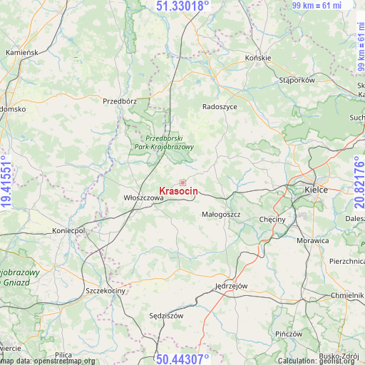
Krasocin GPS coordinates[2]
50° 53' 19.464" North, 20° 7' 7.068" East
| Map corner | latitude | longitude |
|---|---|---|
| Upper-left | 51.33018°, | 19.41551° |
| Center: | 50.88874°, | 20.11863° |
| Lower-right: | 50.44307°, | 20.82176° |
| Map W x H: | 98.6×98.6 km | = 61.3×61.3mi |
| max Lat: | 54.83135° ⇑58.1% North |
| Krasocin: | 50.88874° |
| min Lat: | ⇓41.9% South 49.21328° |
| min Long | Krasocin | max Long |
| 14.20249° | 20.11863° | 24.03723° |
| W 60.3%⇐ | ⇒39.7% E |
Elevation
Elevation of Krasocin is 246 m = 807 ft, and this is 54.6 m = 179 ft above average elevation for this country.
| Max E: |
974 m = 3196 ft | 25.2% |
| Krasocin | 246 m 807 ft | |
| Avg. | 191.4 m = 628 ft | |
Min E: |
-3 m = -10 ft | 74.8% |
See also: Poland elevation on elevation.city.
Geographical zone
Krasocin is located in North temperate zone (between Tropic of Cancer and the Arctic Circle). Distance of this North polar circle is 1742.9 km =1083 mi to North.| Distance of | km | miles | from Krasocin |
|---|---|---|---|
| North Pole | 4348.8 | 2702.2 | to North |
| Arctic Circle | 1742.9 | 1083 | to North |
| Tropic Cancer | 3052.4 | 1896.7 | to South |
| Equator | 5658.3 | 3515.9 | to South |


Nearby cities:
15 places around Krasocin: (largest is in red/bold)
• Czermno
25.4 km =15.8 mi,  345°
345°
• Kluczewsko
14.7 km =9.1 mi,  287°
287°
• Kozłów
7.5 km =4.7 mi,  156°
156°
• Małogoszcz
13.3 km =8.3 mi,  129°
129°
• Nagłowice
23.4 km =14.5 mi,  182°
182°
• Oksa
17.8 km =11.1 mi, 184°
• Piekoszów
24.3 km =15.1 mi,  92°
92°
• Radków
21.5 km =13.4 mi,  205°
205°
• Radoszyce
22.8 km =14.2 mi,  25°
25°
• Secemin
24 km =14.9 mi,  235°
235°
• Strawczyn
22 km =13.7 mi,  74°
74°
• Słupia
14 km =8.7 mi,  6°
6°
• Wola Wiśniowa
11.1 km =6.9 mi,  230°
230°
• Włoszczowa
11.4 km =7.1 mi,  249°
249°
• Łopuszno
11.4 km =7.1 mi,  54°
54°
Sources, notices
• [Note1] Compared only with cities in Poland existing in our database
• [Src1] Map data: © OpenStreetMap contributors (CC-BY-SA)
• [Src2] Other city data from geonames.org with taken over terms of usage.
• [Src3] Geographical zone / Annual Mean Temperature by Robert A. Rohde @ Wikipedia
