Słupia geodata
Słupia (Świętokrzyskie) is a seat of a third-order administrative division; located in Poland in Europe/Warsaw (GMT+2) time zone. With population of 290 people, there are 3624 cities with bigger population in this country. Compared to other cities in Poland, 55.1% of cities are located further ↑North; 60.7% of cities are located further ←West and 82.1% of cities have lower elevation than Słupia. Note1
Administrative division(s):
- Level 1: Świętokrzyskie
- Level 2: Powiat konecki
- Level 3: Słupia (Konecka)


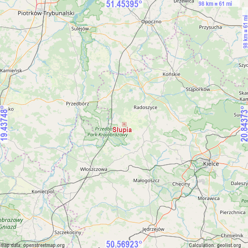
Słupia GPS coordinates[2]
51° 0' 49.32" North, 20° 8' 26.16" East
| Map corner | latitude | longitude |
|---|---|---|
| Upper-left | 51.45395°, | 19.43748° |
| Center: | 51.0137°, | 20.1406° |
| Lower-right: | 50.56923°, | 20.84373° |
| Map W x H: | 98.4×98.4 km | = 61.1×61.1mi |
| max Lat: | 54.83135° ⇑55.1% North |
| Słupia: | 51.0137° |
| min Lat: | ⇓44.9% South 49.21328° |
| min Long | Słupia | max Long |
| 14.20249° | 20.1406° | 24.03723° |
| W 60.7%⇐ | ⇒39.3% E |
Elevation
Elevation of Słupia is 276 m = 906 ft, and this is 84.6 m = 278 ft above average elevation for this country.
| Max E: |
974 m = 3196 ft | 17.9% |
| Słupia | 276 m 906 ft | |
| Avg. | 191.4 m = 628 ft | |
Min E: |
-3 m = -10 ft | 82.1% |
See also: Poland elevation on elevation.city.
Geographical zone
Słupia is located in North temperate zone (between Tropic of Cancer and the Arctic Circle). Distance of this North polar circle is 1729 km =1074.4 mi to North.| Distance of | km | miles | from Słupia |
|---|---|---|---|
| North Pole | 4334.9 | 2693.6 | to North |
| Arctic Circle | 1729 | 1074.4 | to North |
| Tropic Cancer | 3066.3 | 1905.3 | to South |
| Equator | 5672.2 | 3524.5 | to South |


Nearby cities:
15 places around Słupia: (largest is in red/bold)
• Czermno
13.3 km =8.3 mi,  323°
323°
• Fałków
13.8 km =8.6 mi,  349°
349°
• Kluczewsko
18.2 km =11.3 mi,  238°
238°
• Kozłów
20.8 km =12.9 mi,  176°
176°
• Krasocin
14 km =8.7 mi,  186°
186°
• Małogoszcz
24 km =14.9 mi,  158°
158°
• Mniów
24 km =14.9 mi,  90°
90°
• Przedbórz
20.4 km =12.7 mi,  293°
293°
• Radoszyce
10.6 km =6.6 mi,  50°
50°
• Ruda Maleniecka
15.8 km =9.8 mi,  21°
21°
• Smyków
18.5 km =11.5 mi,  79°
79°
• Strawczyn
21.2 km =13.2 mi,  112°
112°
• Wola Wiśniowa
23.3 km =14.5 mi,  205°
205°
• Włoszczowa
21.7 km =13.5 mi, 214°
• Łopuszno
10.6 km =6.6 mi,  133°
133°
Sources, notices
• [Note1] Compared only with cities in Poland existing in our database
• [Src1] Map data: © OpenStreetMap contributors (CC-BY-SA)
• [Src2] Other city data from geonames.org with taken over terms of usage.
• [Src3] Geographical zone / Annual Mean Temperature by Robert A. Rohde @ Wikipedia
