Czermno geodata
Czermno (Świętokrzyskie) is a populated place; located in Poland in Europe/Warsaw (GMT+2) time zone. With population of 850 people, there are 2772 cities with bigger population in this country. Compared to other cities in Poland, 52.3% of cities are located further ↑North; 58.7% of cities are located further ←West and 71.4% of cities have lower elevation than Czermno. Note1


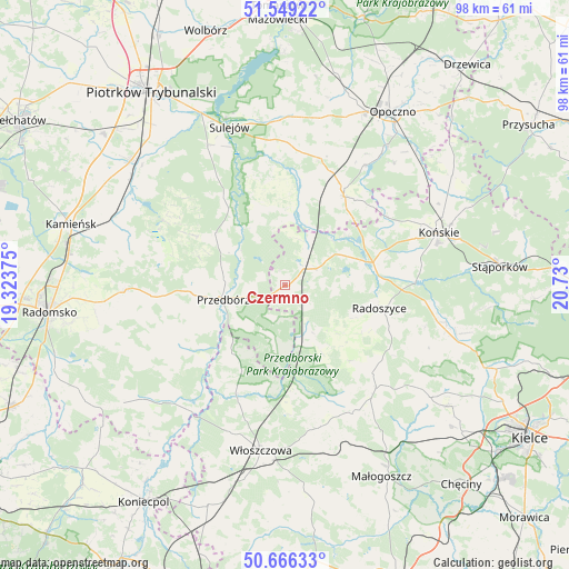
Czermno GPS coordinates[2]
51° 6' 35.568" North, 20° 1' 36.732" East
| Map corner | latitude | longitude |
|---|---|---|
| Upper-left | 51.54922°, | 19.32375° |
| Center: | 51.10988°, | 20.02687° |
| Lower-right: | 50.66633°, | 20.73° |
| Map W x H: | 98.2×98.2 km | = 61×61mi |
| max Lat: | 54.83135° ⇑52.3% North |
| Czermno: | 51.10988° |
| min Lat: | ⇓47.7% South 49.21328° |
| min Long | Czermno | max Long |
| 14.20249° | 20.02687° | 24.03723° |
| W 58.7%⇐ | ⇒41.3% E |
Elevation
Elevation of Czermno is 233 m = 764 ft, and this is 41.6 m = 136 ft above average elevation for this country.
| Max E: |
974 m = 3196 ft | 28.6% |
| Czermno | 233 m 764 ft | |
| Avg. | 191.4 m = 628 ft | |
Min E: |
-3 m = -10 ft | 71.4% |
See also: Poland elevation on elevation.city.
Geographical zone
Czermno is located in North temperate zone (between Tropic of Cancer and the Arctic Circle). Distance of this North polar circle is 1718.3 km =1067.7 mi to North.| Distance of | km | miles | from Czermno |
|---|---|---|---|
| North Pole | 4324.2 | 2686.9 | to North |
| Arctic Circle | 1718.3 | 1067.7 | to North |
| Tropic Cancer | 3077 | 1912 | to South |
| Equator | 5682.9 | 3531.2 | to South |


Nearby cities:
15 places around Czermno: (largest is in red/bold)
• Aleksandrów
18.1 km =11.2 mi,  351°
351°
• Fałków
6.2 km =3.9 mi,  62°
62°
• Kluczewsko
21.6 km =13.4 mi,  200°
200°
• Krasocin
25.4 km =15.8 mi,  165°
165°
• Paradyż
22.6 km =14 mi,  15°
15°
• Przedbórz
11 km =6.8 mi,  257°
257°
• Radoszyce
16.7 km =10.4 mi,  103°
103°
• Ruda Maleniecka
14.3 km =8.9 mi,  73°
73°
• Ręczno
15 km =9.3 mi,  306°
306°
• Smyków
27.1 km =16.8 mi,  105°
105°
• Słupia
13.3 km =8.3 mi,  143°
143°
• Wielgomłyny
21.3 km =13.2 mi,  239°
239°
• Łopuszno
23.8 km =14.8 mi, 138°
• Łęki Szlacheckie
18.2 km =11.3 mi,  298°
298°
• Żarnów
18.3 km =11.4 mi,  34°
34°
Sources, notices
• [Note1] Compared only with cities in Poland existing in our database
• [Src1] Map data: © OpenStreetMap contributors (CC-BY-SA)
• [Src2] Other city data from geonames.org with taken over terms of usage.
• [Src3] Geographical zone / Annual Mean Temperature by Robert A. Rohde @ Wikipedia
