Świnice Warckie geodata
Świnice Warckie (Łódź Voivodeship) is a seat of a third-order administrative division; located in Poland in Europe/Warsaw (GMT+2) time zone. With population of 1,500 people, there are 1837 cities with bigger population in this country. Compared to other cities in Poland, 66.4% of cities are located further ↓South; 61.6% of cities are located further →East and 78.4% of cities have higher elevation than Świnice Warckie. Note1
Administrative division(s):
- Level 1: Łódź Voivodeship
- Level 2: Powiat łęczycki
- Level 3: Świnice Warckie


Świnice Warckie GPS coordinates[2]
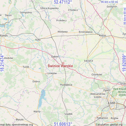
52° 2' 26.592" North, 18° 55' 4.296" East
| Map corner | latitude | longitude |
|---|---|---|
| Upper-left | 52.47112°, | 18.21474° |
| Center: | 52.04072°, | 18.91786° |
| Lower-right: | 51.60613°, | 19.62099° |
| Map W x H: | 96.2×96.2 km | = 59.8×59.8mi |
| max Lat: | 54.83135° ⇑33.6% North |
| Świnice Warckie: | 52.04072° |
| min Lat: | ⇓66.4% South 49.21328° |
| min Long | Świnice Warcki | max Long |
| 14.20249° | 18.91786° | 24.03723° |
| W 38.4%⇐ | ⇒61.6% E |
Elevation
Elevation of Świnice Warckie is 103 m = 338 ft, and this is 88.4 m = 290 ft below average elevation for this country.
| Max E: |
974 m = 3196 ft | 78.4% |
| Avg. | 191.4 m = 628 ft | |
| Świnice Warckie | 103 m = 338 ft | |
Min E: |
-3 m = -10 ft | 21.6% |
See also: Poland elevation on elevation.city.
Geographical zone
Świnice Warckie is located in North temperate zone (between Tropic of Cancer and the Arctic Circle). Distance of this North polar circle is 1614.8 km =1003.4 mi to North.| Distance of | km | miles | from Świnice Warckie |
|---|---|---|---|
| North Pole | 4220.7 | 2622.6 | to North |
| Arctic Circle | 1614.8 | 1003.4 | to North |
| Tropic Cancer | 3180.5 | 1976.3 | to South |
| Equator | 5786.4 | 3595.5 | to South |


Nearby cities:
15 places around Świnice Warckie: (largest is in red/bold)
• Brudzew
22.4 km =13.9 mi,  286°
286°
• Błonie
15.5 km =9.6 mi,  75°
75°
• Dalików
22.2 km =13.8 mi,  141°
141°
• Daszyna
22 km =13.7 mi,  54°
54°
• Dąbie
8.3 km =5.2 mi,  308°
308°
• Grabów
11.2 km =7 mi,  31°
31°
• Grzegorzew
21.9 km =13.6 mi,  324°
324°
• Kłodawa
23.8 km =14.8 mi,  359°
359°
• Olszówka
17.1 km =10.6 mi,  347°
347°
• Parzęczew
22.2 km =13.8 mi,  117°
117°
• Poddębice
16.6 km =10.3 mi,  170°
170°
• Przykona
21.9 km =13.6 mi,  252°
252°
• Uniejów
11.3 km =7 mi,  229°
229°
• Wartkowice
9.2 km =5.7 mi, 141°
• Łęczyca
19.4 km =12.1 mi, 83°
Sources, notices
• [Note1] Compared only with cities in Poland existing in our database
• [Src1] Map data: © OpenStreetMap contributors (CC-BY-SA)
• [Src2] Other city data from geonames.org with taken over terms of usage.
• [Src3] Geographical zone / Annual Mean Temperature by Robert A. Rohde @ Wikipedia
